You are here: Home > Network List > IU - Global Seismograph Network (GSN - IRIS/USGS) Stations List
> Station KIP Kipapa, Hawaii, USA > Earthquake Result Viewer
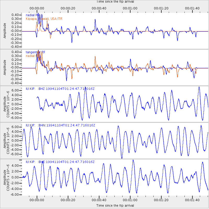
KIP Kipapa, Hawaii, USA - Earthquake Result Viewer
*The percent match for this event was below the threshold and hence no stack was calculated.
| Earthquake location: |
Peru-Brazil Border Region |
| Earthquake latitude/longitude: |
-9.3/-71.3 |
| Earthquake time(UTC): |
1994/11/04 (308) 01:13:20 GMT |
| Earthquake Depth: |
598 km |
| Earthquake Magnitude: |
5.8 MB, 5.9 UNKNOWN, 6.2 MW |
| Earthquake Catalog/Contributor: |
WHDF/NEIC |
|
| Network: |
IU Global Seismograph Network (GSN - IRIS/USGS) |
| Station: |
KIP Kipapa, Hawaii, USA |
| Lat/Lon: |
21.42 N/158.01 W |
| Elevation: |
70 m |
|
| Distance: |
90.3 deg |
| Az: |
291.532 deg |
| Baz: |
99.827 deg |
| Ray Param: |
$rayparam |
*The percent match for this event was below the threshold and hence was not used in the summary stack. |
|
| Radial Match: |
69.37716 % |
| Radial Bump: |
400 |
| Transverse Match: |
62.746803 % |
| Transverse Bump: |
391 |
| SOD ConfigId: |
4480 |
| Insert Time: |
2010-03-03 16:39:29.383 +0000 |
| GWidth: |
2.5 |
| Max Bumps: |
400 |
| Tol: |
0.001 |
|
Signal To Noise
| Channel | StoN | STA | LTA |
| IU:KIP: :BHN:19941104T01:24:47.716016Z | 1.3273278 | 3.7956318E-6 | 2.8596037E-6 |
| IU:KIP: :BHE:19941104T01:24:47.716016Z | 2.2254968 | 3.3109113E-6 | 1.4877179E-6 |
| IU:KIP: :BHZ:19941104T01:24:47.716016Z | 2.6717064 | 4.6930963E-6 | 1.7565914E-6 |
| Arrivals |
| Ps | |
| PpPs | |
| PsPs/PpSs | |


