You are here: Home > Network List > IU - Global Seismograph Network (GSN - IRIS/USGS) Stations List
> Station KIP Kipapa, Hawaii, USA > Earthquake Result Viewer
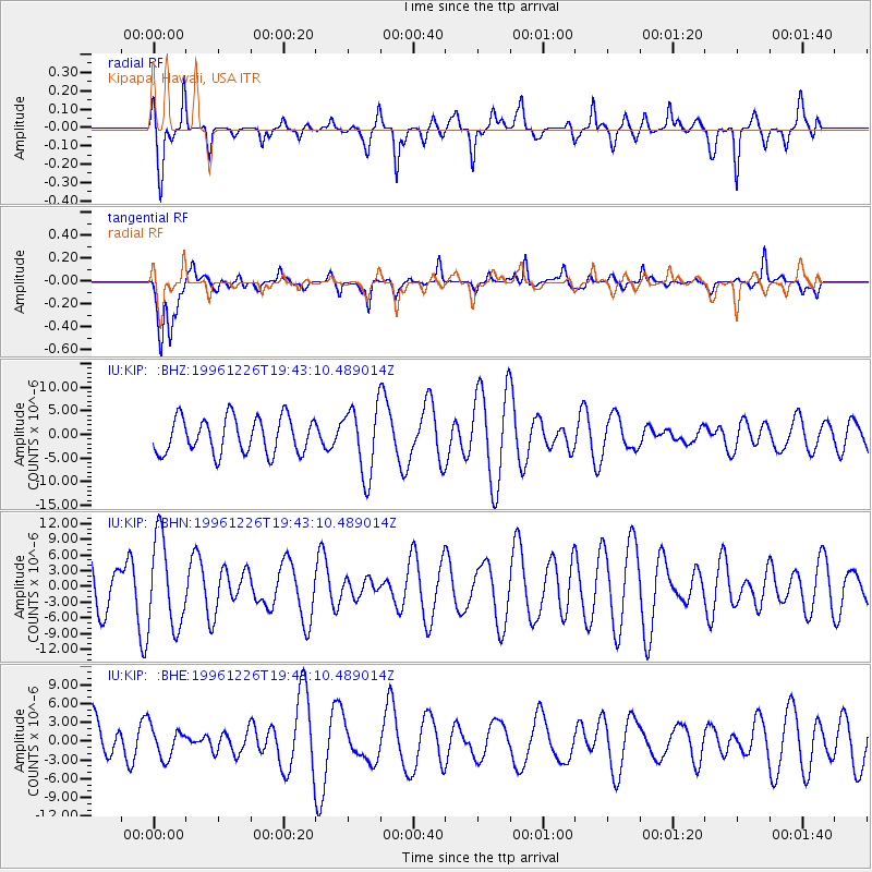
KIP Kipapa, Hawaii, USA - Earthquake Result Viewer
*The percent match for this event was below the threshold and hence no stack was calculated.
| Earthquake location: |
New Britain Region, P.N.G. |
| Earthquake latitude/longitude: |
-5.4/151.4 |
| Earthquake time(UTC): |
1996/12/26 (361) 19:34:11 GMT |
| Earthquake Depth: |
107 km |
| Earthquake Magnitude: |
5.5 MS, 5.3 MB, 5.8 UNKNOWN, 5.8 MW |
| Earthquake Catalog/Contributor: |
WHDF/NEIC |
|
| Network: |
IU Global Seismograph Network (GSN - IRIS/USGS) |
| Station: |
KIP Kipapa, Hawaii, USA |
| Lat/Lon: |
21.42 N/158.01 W |
| Elevation: |
70 m |
|
| Distance: |
56.3 deg |
| Az: |
59.966 deg |
| Baz: |
247.691 deg |
| Ray Param: |
$rayparam |
*The percent match for this event was below the threshold and hence was not used in the summary stack. |
|
| Radial Match: |
57.30322 % |
| Radial Bump: |
305 |
| Transverse Match: |
65.59717 % |
| Transverse Bump: |
366 |
| SOD ConfigId: |
4480 |
| Insert Time: |
2010-03-03 16:39:30.246 +0000 |
| GWidth: |
2.5 |
| Max Bumps: |
400 |
| Tol: |
0.001 |
|
Signal To Noise
| Channel | StoN | STA | LTA |
| IU:KIP: :BHN:19961226T19:43:10.489014Z | 2.4782338 | 8.399678E-6 | 3.389381E-6 |
| IU:KIP: :BHE:19961226T19:43:10.489014Z | 0.73106503 | 2.4330723E-6 | 3.3281199E-6 |
| IU:KIP: :BHZ:19961226T19:43:10.489014Z | 1.9111798 | 7.2121748E-6 | 3.7736768E-6 |
| Arrivals |
| Ps | |
| PpPs | |
| PsPs/PpSs | |


