You are here: Home > Network List > IU - Global Seismograph Network (GSN - IRIS/USGS) Stations List
> Station KIP Kipapa, Hawaii, USA > Earthquake Result Viewer
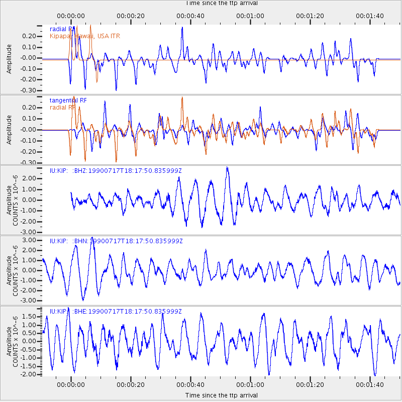
KIP Kipapa, Hawaii, USA - Earthquake Result Viewer
*The percent match for this event was below the threshold and hence no stack was calculated.
| Earthquake location: |
Luzon, Philippines |
| Earthquake latitude/longitude: |
16.4/120.9 |
| Earthquake time(UTC): |
1990/07/17 (198) 18:06:34 GMT |
| Earthquake Depth: |
12 km |
| Earthquake Magnitude: |
5.5 MB, 6.1 MS |
| Earthquake Catalog/Contributor: |
WHDF/NEIC |
|
| Network: |
IU Global Seismograph Network (GSN - IRIS/USGS) |
| Station: |
KIP Kipapa, Hawaii, USA |
| Lat/Lon: |
21.42 N/158.01 W |
| Elevation: |
70 m |
|
| Distance: |
76.1 deg |
| Az: |
71.482 deg |
| Baz: |
282.326 deg |
| Ray Param: |
$rayparam |
*The percent match for this event was below the threshold and hence was not used in the summary stack. |
|
| Radial Match: |
71.99515 % |
| Radial Bump: |
400 |
| Transverse Match: |
57.35479 % |
| Transverse Bump: |
388 |
| SOD ConfigId: |
4480 |
| Insert Time: |
2010-03-03 16:39:44.925 +0000 |
| GWidth: |
2.5 |
| Max Bumps: |
400 |
| Tol: |
0.001 |
|
Signal To Noise
| Channel | StoN | STA | LTA |
| IU:KIP: :BHN:19900717T18:17:50.835999Z | 2.0196517 | 1.8419025E-6 | 9.1199024E-7 |
| IU:KIP: :BHE:19900717T18:17:50.835999Z | 1.5962843 | 1.0749219E-6 | 6.7339E-7 |
| IU:KIP: :BHZ:19900717T18:17:50.835999Z | 1.5243229 | 6.814678E-7 | 4.4706263E-7 |
| Arrivals |
| Ps | |
| PpPs | |
| PsPs/PpSs | |


