You are here: Home > Network List > US - United States National Seismic Network Stations List
> Station EGMT Eagleton, Montana, USA > Earthquake Result Viewer
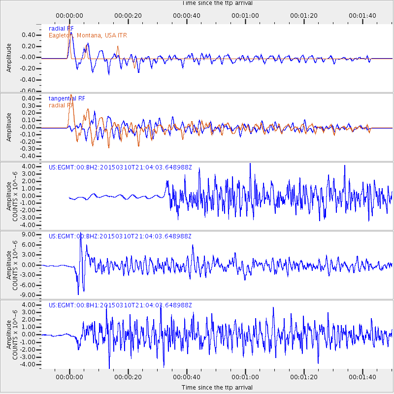
EGMT Eagleton, Montana, USA - Earthquake Result Viewer
*The percent match for this event was below the threshold and hence no stack was calculated.
| Earthquake location: |
Northern Colombia |
| Earthquake latitude/longitude: |
6.8/-73.0 |
| Earthquake time(UTC): |
2015/03/10 (069) 20:55:43 GMT |
| Earthquake Depth: |
147 km |
| Earthquake Magnitude: |
6.2 MWB |
| Earthquake Catalog/Contributor: |
NEIC PDE/NEIC COMCAT |
|
| Network: |
US United States National Seismic Network |
| Station: |
EGMT Eagleton, Montana, USA |
| Lat/Lon: |
48.02 N/109.75 W |
| Elevation: |
1055 m |
|
| Distance: |
51.6 deg |
| Az: |
329.155 deg |
| Baz: |
130.675 deg |
| Ray Param: |
$rayparam |
*The percent match for this event was below the threshold and hence was not used in the summary stack. |
|
| Radial Match: |
77.062515 % |
| Radial Bump: |
400 |
| Transverse Match: |
80.32834 % |
| Transverse Bump: |
400 |
| SOD ConfigId: |
872571 |
| Insert Time: |
2015-03-24 21:19:32.748 +0000 |
| GWidth: |
2.5 |
| Max Bumps: |
400 |
| Tol: |
0.001 |
|
Signal To Noise
| Channel | StoN | STA | LTA |
| US:EGMT:00:BHZ:20150310T21:04:03.648988Z | 41.298103 | 3.8049982E-6 | 9.213494E-8 |
| US:EGMT:00:BH1:20150310T21:04:03.648988Z | 6.7425246 | 7.617278E-7 | 1.1297368E-7 |
| US:EGMT:00:BH2:20150310T21:04:03.648988Z | 4.2096677 | 8.308951E-7 | 1.9737784E-7 |
| Arrivals |
| Ps | |
| PpPs | |
| PsPs/PpSs | |


