You are here: Home > Network List > TA - USArray Transportable Network (new EarthScope stations) Stations List
> Station R11A Troy Canyon, Currant, NV, USA > Earthquake Result Viewer
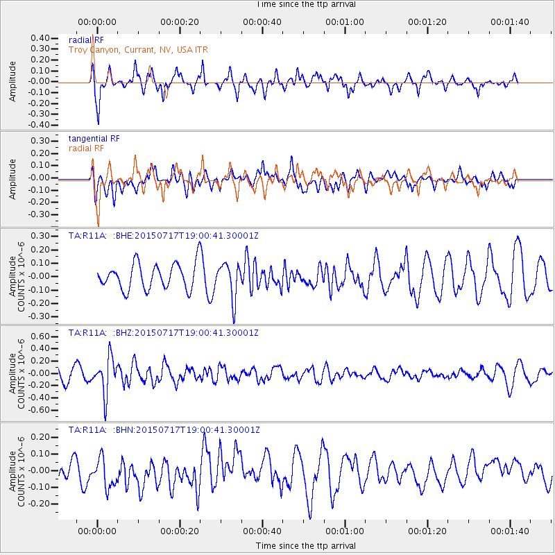
R11A Troy Canyon, Currant, NV, USA - Earthquake Result Viewer
*The percent match for this event was below the threshold and hence no stack was calculated.
| Earthquake location: |
Fiji Islands Region |
| Earthquake latitude/longitude: |
-18.1/-178.2 |
| Earthquake time(UTC): |
2015/07/17 (198) 18:49:53 GMT |
| Earthquake Depth: |
537 km |
| Earthquake Magnitude: |
5.8 MWW, 5.8 MWC, 5.9 MWB, 5.9 MWC |
| Earthquake Catalog/Contributor: |
NEIC PDE/NEIC COMCAT |
|
| Network: |
TA USArray Transportable Network (new EarthScope stations) |
| Station: |
R11A Troy Canyon, Currant, NV, USA |
| Lat/Lon: |
38.35 N/115.59 W |
| Elevation: |
1756 m |
|
| Distance: |
81.2 deg |
| Az: |
44.948 deg |
| Baz: |
238.709 deg |
| Ray Param: |
$rayparam |
*The percent match for this event was below the threshold and hence was not used in the summary stack. |
|
| Radial Match: |
67.096466 % |
| Radial Bump: |
367 |
| Transverse Match: |
47.730793 % |
| Transverse Bump: |
400 |
| SOD ConfigId: |
7422571 |
| Insert Time: |
2019-04-19 20:59:23.334 +0000 |
| GWidth: |
2.5 |
| Max Bumps: |
400 |
| Tol: |
0.001 |
|
Signal To Noise
| Channel | StoN | STA | LTA |
| TA:R11A: :BHZ:20150717T19:00:41.30001Z | 2.984414 | 3.0484458E-7 | 1.02145535E-7 |
| TA:R11A: :BHN:20150717T19:00:41.30001Z | 1.673918 | 9.5128904E-8 | 5.6830086E-8 |
| TA:R11A: :BHE:20150717T19:00:41.30001Z | 1.3402036 | 1.3734753E-7 | 1.0248257E-7 |
| Arrivals |
| Ps | |
| PpPs | |
| PsPs/PpSs | |


