You are here: Home > Network List > UW - Pacific Northwest Regional Seismic Network Stations List
> Station LEBA Lebam, WA, USA > Earthquake Result Viewer
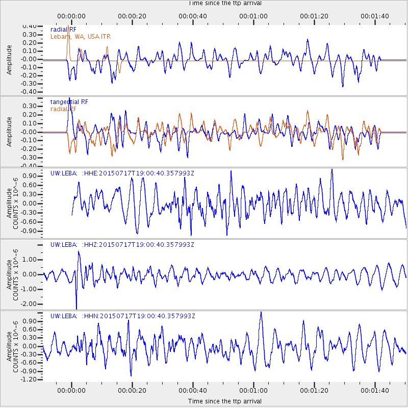
LEBA Lebam, WA, USA - Earthquake Result Viewer
*The percent match for this event was below the threshold and hence no stack was calculated.
| Earthquake location: |
Fiji Islands Region |
| Earthquake latitude/longitude: |
-18.1/-178.2 |
| Earthquake time(UTC): |
2015/07/17 (198) 18:49:53 GMT |
| Earthquake Depth: |
537 km |
| Earthquake Magnitude: |
5.8 MWW, 5.8 MWC, 5.9 MWB, 5.9 MWC |
| Earthquake Catalog/Contributor: |
NEIC PDE/NEIC COMCAT |
|
| Network: |
UW Pacific Northwest Regional Seismic Network |
| Station: |
LEBA Lebam, WA, USA |
| Lat/Lon: |
46.55 N/123.56 W |
| Elevation: |
73 m |
|
| Distance: |
81.0 deg |
| Az: |
34.74 deg |
| Baz: |
231.742 deg |
| Ray Param: |
$rayparam |
*The percent match for this event was below the threshold and hence was not used in the summary stack. |
|
| Radial Match: |
56.770096 % |
| Radial Bump: |
400 |
| Transverse Match: |
53.881863 % |
| Transverse Bump: |
400 |
| SOD ConfigId: |
7422571 |
| Insert Time: |
2019-04-19 21:00:22.089 +0000 |
| GWidth: |
2.5 |
| Max Bumps: |
400 |
| Tol: |
0.001 |
|
Signal To Noise
| Channel | StoN | STA | LTA |
| UW:LEBA: :HHZ:20150717T19:00:40.357993Z | 3.8597062 | 8.1384053E-7 | 2.1085556E-7 |
| UW:LEBA: :HHN:20150717T19:00:40.357993Z | 0.8966853 | 2.2688822E-7 | 2.5302992E-7 |
| UW:LEBA: :HHE:20150717T19:00:40.357993Z | 0.6391175 | 2.6795433E-7 | 4.1925676E-7 |
| Arrivals |
| Ps | |
| PpPs | |
| PsPs/PpSs | |


