You are here: Home > Network List > UW - Pacific Northwest Regional Seismic Network Stations List
> Station UMAT Pilot Rock, OR, USA > Earthquake Result Viewer
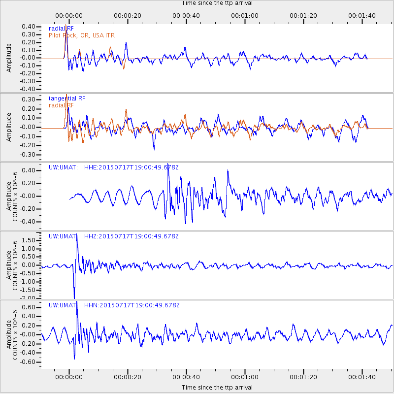
UMAT Pilot Rock, OR, USA - Earthquake Result Viewer
*The percent match for this event was below the threshold and hence no stack was calculated.
| Earthquake location: |
Fiji Islands Region |
| Earthquake latitude/longitude: |
-18.1/-178.2 |
| Earthquake time(UTC): |
2015/07/17 (198) 18:49:53 GMT |
| Earthquake Depth: |
537 km |
| Earthquake Magnitude: |
5.8 MWW, 5.8 MWC, 5.9 MWB, 5.9 MWC |
| Earthquake Catalog/Contributor: |
NEIC PDE/NEIC COMCAT |
|
| Network: |
UW Pacific Northwest Regional Seismic Network |
| Station: |
UMAT Pilot Rock, OR, USA |
| Lat/Lon: |
45.29 N/118.96 W |
| Elevation: |
1318 m |
|
| Distance: |
82.8 deg |
| Az: |
37.686 deg |
| Baz: |
235.453 deg |
| Ray Param: |
$rayparam |
*The percent match for this event was below the threshold and hence was not used in the summary stack. |
|
| Radial Match: |
67.34783 % |
| Radial Bump: |
400 |
| Transverse Match: |
69.648766 % |
| Transverse Bump: |
400 |
| SOD ConfigId: |
7422571 |
| Insert Time: |
2019-04-19 21:00:31.456 +0000 |
| GWidth: |
2.5 |
| Max Bumps: |
400 |
| Tol: |
0.001 |
|
Signal To Noise
| Channel | StoN | STA | LTA |
| UW:UMAT: :HHZ:20150717T19:00:49.678Z | 5.4009233 | 7.3165614E-7 | 1.3546871E-7 |
| UW:UMAT: :HHN:20150717T19:00:49.678Z | 3.6450355 | 2.524496E-7 | 6.9258476E-8 |
| UW:UMAT: :HHE:20150717T19:00:49.678Z | 2.7425585 | 1.9942718E-7 | 7.271574E-8 |
| Arrivals |
| Ps | |
| PpPs | |
| PsPs/PpSs | |


