You are here: Home > Network List > IU - Global Seismograph Network (GSN - IRIS/USGS) Stations List
> Station KIP Kipapa, Hawaii, USA > Earthquake Result Viewer
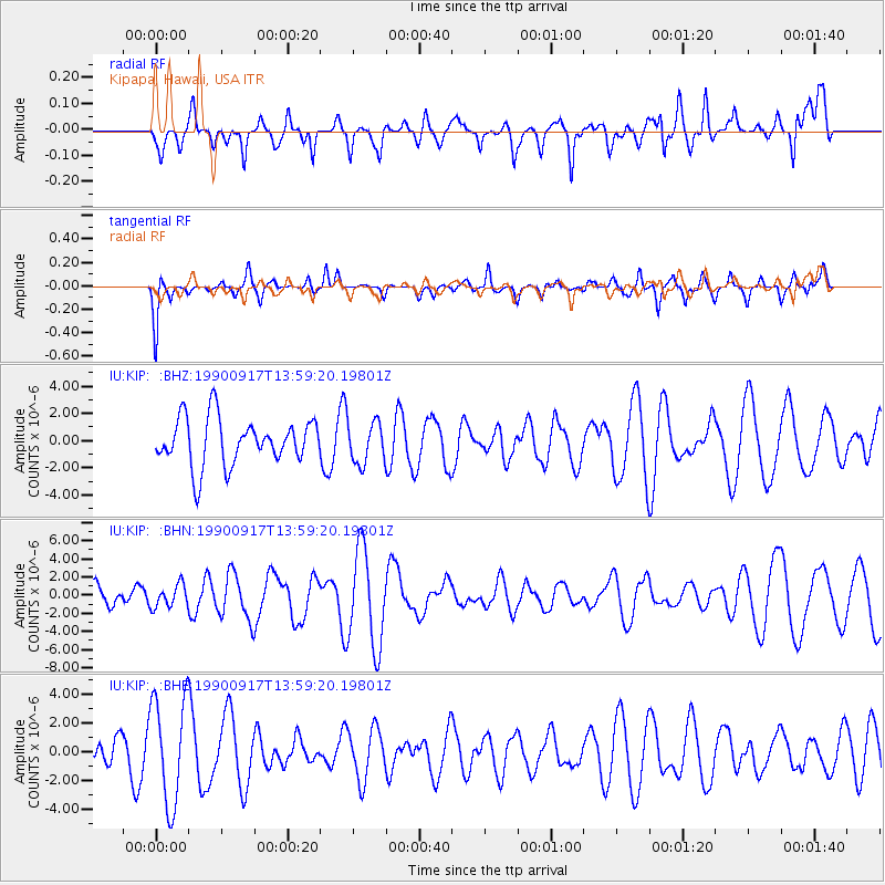
KIP Kipapa, Hawaii, USA - Earthquake Result Viewer
*The percent match for this event was below the threshold and hence no stack was calculated.
| Earthquake location: |
Macquarie Island Region |
| Earthquake latitude/longitude: |
-53.3/159.4 |
| Earthquake time(UTC): |
1990/09/17 (260) 13:47:26 GMT |
| Earthquake Depth: |
10 km |
| Earthquake Magnitude: |
5.9 MB, 6.0 MS |
| Earthquake Catalog/Contributor: |
WHDF/NEIC |
|
| Network: |
IU Global Seismograph Network (GSN - IRIS/USGS) |
| Station: |
KIP Kipapa, Hawaii, USA |
| Lat/Lon: |
21.42 N/158.01 W |
| Elevation: |
70 m |
|
| Distance: |
83.0 deg |
| Az: |
39.401 deg |
| Baz: |
204.137 deg |
| Ray Param: |
$rayparam |
*The percent match for this event was below the threshold and hence was not used in the summary stack. |
|
| Radial Match: |
53.4684 % |
| Radial Bump: |
400 |
| Transverse Match: |
55.268772 % |
| Transverse Bump: |
348 |
| SOD ConfigId: |
4480 |
| Insert Time: |
2010-03-03 16:40:24.456 +0000 |
| GWidth: |
2.5 |
| Max Bumps: |
400 |
| Tol: |
0.001 |
|
Signal To Noise
| Channel | StoN | STA | LTA |
| IU:KIP: :BHN:19900917T13:59:20.19801Z | 0.64865893 | 1.2391362E-6 | 1.9103045E-6 |
| IU:KIP: :BHE:19900917T13:59:20.19801Z | 3.6563408 | 3.7156701E-6 | 1.0162264E-6 |
| IU:KIP: :BHZ:19900917T13:59:20.19801Z | 0.8722709 | 1.5021512E-6 | 1.7221155E-6 |
| Arrivals |
| Ps | |
| PpPs | |
| PsPs/PpSs | |


