You are here: Home > Network List > IU - Global Seismograph Network (GSN - IRIS/USGS) Stations List
> Station KIP Kipapa, Hawaii, USA > Earthquake Result Viewer
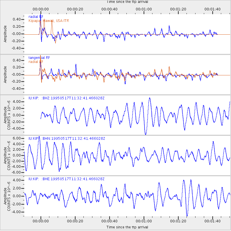
KIP Kipapa, Hawaii, USA - Earthquake Result Viewer
*The percent match for this event was below the threshold and hence no stack was calculated.
| Earthquake location: |
Southeast Of Loyalty Islands |
| Earthquake latitude/longitude: |
-23.0/170.1 |
| Earthquake time(UTC): |
1995/05/17 (137) 11:23:51 GMT |
| Earthquake Depth: |
33 km |
| Earthquake Magnitude: |
5.7 MB, 6.5 MS, 6.5 UNKNOWN, 6.2 MW |
| Earthquake Catalog/Contributor: |
WHDF/NEIC |
|
| Network: |
IU Global Seismograph Network (GSN - IRIS/USGS) |
| Station: |
KIP Kipapa, Hawaii, USA |
| Lat/Lon: |
21.42 N/158.01 W |
| Elevation: |
70 m |
|
| Distance: |
54.0 deg |
| Az: |
37.482 deg |
| Baz: |
216.989 deg |
| Ray Param: |
$rayparam |
*The percent match for this event was below the threshold and hence was not used in the summary stack. |
|
| Radial Match: |
68.383224 % |
| Radial Bump: |
400 |
| Transverse Match: |
70.70802 % |
| Transverse Bump: |
372 |
| SOD ConfigId: |
4480 |
| Insert Time: |
2010-03-03 16:40:29.065 +0000 |
| GWidth: |
2.5 |
| Max Bumps: |
400 |
| Tol: |
0.001 |
|
Signal To Noise
| Channel | StoN | STA | LTA |
| IU:KIP: :BHN:19950517T11:32:41.466028Z | 1.934634 | 3.7097827E-6 | 1.9175632E-6 |
| IU:KIP: :BHE:19950517T11:32:41.466028Z | 0.49551114 | 4.48798E-7 | 9.0572735E-7 |
| IU:KIP: :BHZ:19950517T11:32:41.466028Z | 0.98500115 | 1.3105054E-6 | 1.3304607E-6 |
| Arrivals |
| Ps | |
| PpPs | |
| PsPs/PpSs | |


