You are here: Home > Network List > IU - Global Seismograph Network (GSN - IRIS/USGS) Stations List
> Station KIP Kipapa, Hawaii, USA > Earthquake Result Viewer
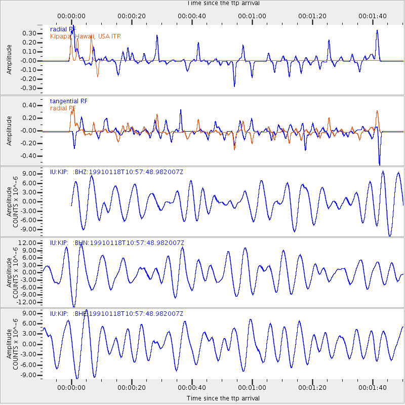
KIP Kipapa, Hawaii, USA - Earthquake Result Viewer
*The percent match for this event was below the threshold and hence no stack was calculated.
| Earthquake location: |
South Of Australia |
| Earthquake latitude/longitude: |
-51.2/139.3 |
| Earthquake time(UTC): |
1991/01/18 (018) 10:45:17 GMT |
| Earthquake Depth: |
10 km |
| Earthquake Magnitude: |
5.6 MB, 6.4 MS, 6.2 UNKNOWN |
| Earthquake Catalog/Contributor: |
WHDF/NEIC |
|
| Network: |
IU Global Seismograph Network (GSN - IRIS/USGS) |
| Station: |
KIP Kipapa, Hawaii, USA |
| Lat/Lon: |
21.42 N/158.01 W |
| Elevation: |
70 m |
|
| Distance: |
90.8 deg |
| Az: |
55.901 deg |
| Baz: |
213.967 deg |
| Ray Param: |
$rayparam |
*The percent match for this event was below the threshold and hence was not used in the summary stack. |
|
| Radial Match: |
47.70089 % |
| Radial Bump: |
365 |
| Transverse Match: |
50.829216 % |
| Transverse Bump: |
400 |
| SOD ConfigId: |
4480 |
| Insert Time: |
2010-03-03 16:40:37.270 +0000 |
| GWidth: |
2.5 |
| Max Bumps: |
400 |
| Tol: |
0.001 |
|
Signal To Noise
| Channel | StoN | STA | LTA |
| IU:KIP: :BHN:19910118T10:57:48.982007Z | 2.4988463 | 8.701089E-6 | 3.4820425E-6 |
| IU:KIP: :BHE:19910118T10:57:48.982007Z | 1.8239952 | 6.58128E-6 | 3.6081674E-6 |
| IU:KIP: :BHZ:19910118T10:57:48.982007Z | 0.31097263 | 1.4006175E-6 | 4.5039897E-6 |
| Arrivals |
| Ps | |
| PpPs | |
| PsPs/PpSs | |


