You are here: Home > Network List > IU - Global Seismograph Network (GSN - IRIS/USGS) Stations List
> Station KIP Kipapa, Hawaii, USA > Earthquake Result Viewer
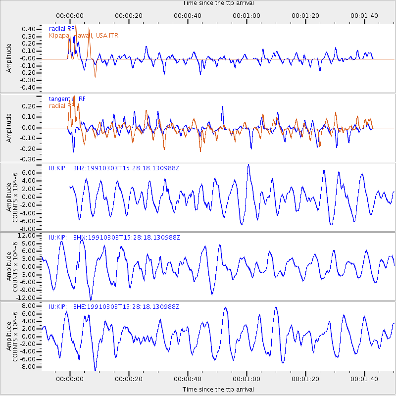
KIP Kipapa, Hawaii, USA - Earthquake Result Viewer
*The percent match for this event was below the threshold and hence no stack was calculated.
| Earthquake location: |
Tonga Islands |
| Earthquake latitude/longitude: |
-21.8/-175.2 |
| Earthquake time(UTC): |
1991/03/03 (062) 15:20:28 GMT |
| Earthquake Depth: |
43 km |
| Earthquake Magnitude: |
6.1 MB, 6.1 MS |
| Earthquake Catalog/Contributor: |
WHDF/NEIC |
|
| Network: |
IU Global Seismograph Network (GSN - IRIS/USGS) |
| Station: |
KIP Kipapa, Hawaii, USA |
| Lat/Lon: |
21.42 N/158.01 W |
| Elevation: |
70 m |
|
| Distance: |
46.1 deg |
| Az: |
22.42 deg |
| Baz: |
202.354 deg |
| Ray Param: |
$rayparam |
*The percent match for this event was below the threshold and hence was not used in the summary stack. |
|
| Radial Match: |
65.25796 % |
| Radial Bump: |
400 |
| Transverse Match: |
59.33346 % |
| Transverse Bump: |
336 |
| SOD ConfigId: |
4480 |
| Insert Time: |
2010-03-03 16:40:41.101 +0000 |
| GWidth: |
2.5 |
| Max Bumps: |
400 |
| Tol: |
0.001 |
|
Signal To Noise
| Channel | StoN | STA | LTA |
| IU:KIP: :BHN:19910303T15:28:18.130988Z | 1.9444699 | 6.5445897E-6 | 3.365745E-6 |
| IU:KIP: :BHE:19910303T15:28:18.130988Z | 1.7693079 | 3.4494233E-6 | 1.949589E-6 |
| IU:KIP: :BHZ:19910303T15:28:18.130988Z | 0.8973265 | 2.4011729E-6 | 2.675919E-6 |
| Arrivals |
| Ps | |
| PpPs | |
| PsPs/PpSs | |


