You are here: Home > Network List > US - United States National Seismic Network Stations List
> Station MNTX Cornudas Mountains, Texas, USA > Earthquake Result Viewer
MNTX Cornudas Mountains, Texas, USA - Earthquake Result Viewer
| Earthquake location: |
Northern Colombia |
| Earthquake latitude/longitude: |
6.8/-73.0 |
| Earthquake time(UTC): |
2015/03/10 (069) 20:55:43 GMT |
| Earthquake Depth: |
147 km |
| Earthquake Magnitude: |
6.2 MWB |
| Earthquake Catalog/Contributor: |
NEIC PDE/NEIC COMCAT |
|
| Network: |
US United States National Seismic Network |
| Station: |
MNTX Cornudas Mountains, Texas, USA |
| Lat/Lon: |
31.70 N/105.38 W |
| Elevation: |
404 m |
|
| Distance: |
39.0 deg |
| Az: |
313.576 deg |
| Baz: |
122.439 deg |
| Ray Param: |
0.07467893 |
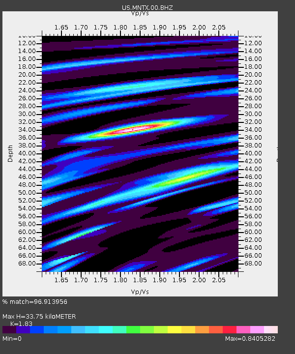
| Estimated Moho Depth: |
33.75 km |
| Estimated Crust Vp/Vs: |
1.83 |
| Assumed Crust Vp: |
6.361 km/s |
| Estimated Crust Vs: |
3.476 km/s |
| Estimated Crust Poisson's Ratio: |
0.29 |
|
| Radial Match: |
96.913956 % |
| Radial Bump: |
278 |
| Transverse Match: |
86.08365 % |
| Transverse Bump: |
339 |
| SOD ConfigId: |
872571 |
| Insert Time: |
2015-03-24 21:20:23.926 +0000 |
| GWidth: |
2.5 |
| Max Bumps: |
400 |
| Tol: |
0.001 |
|

Signal To Noise
| Channel | StoN | STA | LTA |
| US:MNTX:00:BHZ:20150310T21:02:25.325013Z | 58.516582 | 5.360438E-6 | 9.160546E-8 |
| US:MNTX:00:BH1:20150310T21:02:25.325013Z | 31.480717 | 2.5356776E-6 | 8.054701E-8 |
| US:MNTX:00:BH2:20150310T21:02:25.325013Z | 27.948046 | 1.67201E-6 | 5.982565E-8 |
| Arrivals |
| Ps | 4.7 SECOND |
| PpPs | 14 SECOND |
| PsPs/PpSs | 19 SECOND |


