You are here: Home > Network List > IU - Global Seismograph Network (GSN - IRIS/USGS) Stations List
> Station KIP Kipapa, Hawaii, USA > Earthquake Result Viewer
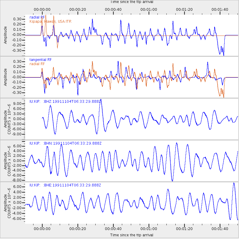
KIP Kipapa, Hawaii, USA - Earthquake Result Viewer
*The percent match for this event was below the threshold and hence no stack was calculated.
| Earthquake location: |
New Britain Region, P.N.G. |
| Earthquake latitude/longitude: |
-6.1/148.1 |
| Earthquake time(UTC): |
1991/11/04 (308) 06:24:08 GMT |
| Earthquake Depth: |
99 km |
| Earthquake Magnitude: |
5.7 MB |
| Earthquake Catalog/Contributor: |
WHDF/NEIC |
|
| Network: |
IU Global Seismograph Network (GSN - IRIS/USGS) |
| Station: |
KIP Kipapa, Hawaii, USA |
| Lat/Lon: |
21.42 N/158.01 W |
| Elevation: |
70 m |
|
| Distance: |
59.5 deg |
| Az: |
60.867 deg |
| Baz: |
248.781 deg |
| Ray Param: |
$rayparam |
*The percent match for this event was below the threshold and hence was not used in the summary stack. |
|
| Radial Match: |
64.344086 % |
| Radial Bump: |
400 |
| Transverse Match: |
64.9125 % |
| Transverse Bump: |
296 |
| SOD ConfigId: |
4480 |
| Insert Time: |
2010-03-03 16:41:23.860 +0000 |
| GWidth: |
2.5 |
| Max Bumps: |
400 |
| Tol: |
0.001 |
|
Signal To Noise
| Channel | StoN | STA | LTA |
| IU:KIP: :BHN:19911104T06:33:29.888Z | 1.2340201 | 3.1458906E-6 | 2.5493025E-6 |
| IU:KIP: :BHE:19911104T06:33:29.888Z | 1.8723387 | 2.3591622E-6 | 1.2600083E-6 |
| IU:KIP: :BHZ:19911104T06:33:29.888Z | 1.8311675 | 6.627644E-6 | 3.6193542E-6 |
| Arrivals |
| Ps | |
| PpPs | |
| PsPs/PpSs | |


