You are here: Home > Network List > IU - Global Seismograph Network (GSN - IRIS/USGS) Stations List
> Station KIP Kipapa, Hawaii, USA > Earthquake Result Viewer
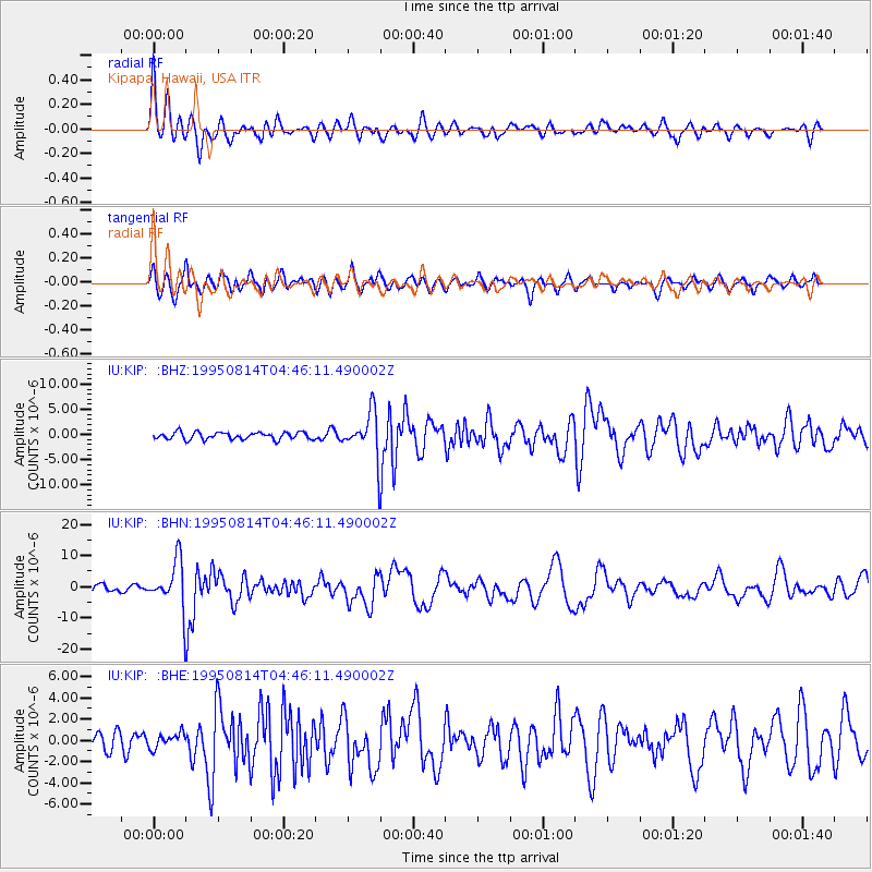
KIP Kipapa, Hawaii, USA - Earthquake Result Viewer
*The percent match for this event was below the threshold and hence no stack was calculated.
| Earthquake location: |
New Britain Region, P.N.G. |
| Earthquake latitude/longitude: |
-4.8/151.5 |
| Earthquake time(UTC): |
1995/08/14 (226) 04:37:17 GMT |
| Earthquake Depth: |
126 km |
| Earthquake Magnitude: |
6.3 MB, 6.3 MS, 6.4 UNKNOWN |
| Earthquake Catalog/Contributor: |
WHDF/NEIC |
|
| Network: |
IU Global Seismograph Network (GSN - IRIS/USGS) |
| Station: |
KIP Kipapa, Hawaii, USA |
| Lat/Lon: |
21.42 N/158.01 W |
| Elevation: |
70 m |
|
| Distance: |
55.9 deg |
| Az: |
60.212 deg |
| Baz: |
248.154 deg |
| Ray Param: |
$rayparam |
*The percent match for this event was below the threshold and hence was not used in the summary stack. |
|
| Radial Match: |
72.56134 % |
| Radial Bump: |
400 |
| Transverse Match: |
71.25182 % |
| Transverse Bump: |
400 |
| SOD ConfigId: |
4480 |
| Insert Time: |
2010-03-03 16:41:35.862 +0000 |
| GWidth: |
2.5 |
| Max Bumps: |
400 |
| Tol: |
0.001 |
|
Signal To Noise
| Channel | StoN | STA | LTA |
| IU:KIP: :BHN:19950814T04:46:11.490002Z | 7.0263658 | 7.749075E-6 | 1.1028567E-6 |
| IU:KIP: :BHE:19950814T04:46:11.490002Z | 1.0533541 | 7.068436E-7 | 6.710408E-7 |
| IU:KIP: :BHZ:19950814T04:46:11.490002Z | 6.049891 | 4.3330847E-6 | 7.162253E-7 |
| Arrivals |
| Ps | |
| PpPs | |
| PsPs/PpSs | |


