You are here: Home > Network List > IU - Global Seismograph Network (GSN - IRIS/USGS) Stations List
> Station KIP Kipapa, Hawaii, USA > Earthquake Result Viewer
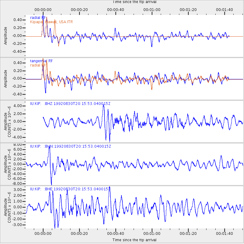
KIP Kipapa, Hawaii, USA - Earthquake Result Viewer
*The percent match for this event was below the threshold and hence no stack was calculated.
| Earthquake location: |
Fiji Islands Region |
| Earthquake latitude/longitude: |
-17.7/-178.8 |
| Earthquake time(UTC): |
1992/08/30 (243) 20:09:06 GMT |
| Earthquake Depth: |
573 km |
| Earthquake Magnitude: |
5.8 MB |
| Earthquake Catalog/Contributor: |
WHDF/NEIC |
|
| Network: |
IU Global Seismograph Network (GSN - IRIS/USGS) |
| Station: |
KIP Kipapa, Hawaii, USA |
| Lat/Lon: |
21.42 N/158.01 W |
| Elevation: |
70 m |
|
| Distance: |
43.9 deg |
| Az: |
28.435 deg |
| Baz: |
209.147 deg |
| Ray Param: |
$rayparam |
*The percent match for this event was below the threshold and hence was not used in the summary stack. |
|
| Radial Match: |
61.135662 % |
| Radial Bump: |
361 |
| Transverse Match: |
63.341713 % |
| Transverse Bump: |
380 |
| SOD ConfigId: |
4480 |
| Insert Time: |
2010-03-03 16:41:43.929 +0000 |
| GWidth: |
2.5 |
| Max Bumps: |
400 |
| Tol: |
0.001 |
|
Signal To Noise
| Channel | StoN | STA | LTA |
| IU:KIP: :BHN:19920830T20:15:53.040015Z | 7.375228 | 3.6372726E-6 | 4.9317424E-7 |
| IU:KIP: :BHE:19920830T20:15:53.040015Z | 1.9876682 | 1.025745E-6 | 5.1605446E-7 |
| IU:KIP: :BHZ:19920830T20:15:53.040015Z | 3.2829287 | 2.167339E-6 | 6.6018464E-7 |
| Arrivals |
| Ps | |
| PpPs | |
| PsPs/PpSs | |


