You are here: Home > Network List > IU - Global Seismograph Network (GSN - IRIS/USGS) Stations List
> Station KIP Kipapa, Hawaii, USA > Earthquake Result Viewer
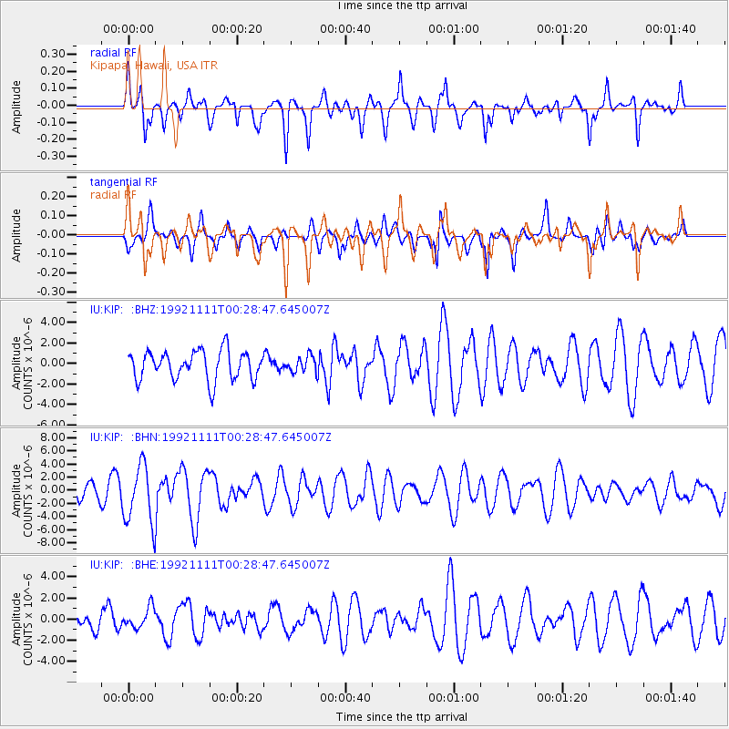
KIP Kipapa, Hawaii, USA - Earthquake Result Viewer
*The percent match for this event was below the threshold and hence no stack was calculated.
| Earthquake location: |
Near N Coast Of New Guinea, P.N.G. |
| Earthquake latitude/longitude: |
-2.9/141.5 |
| Earthquake time(UTC): |
1992/11/11 (316) 00:18:49 GMT |
| Earthquake Depth: |
33 km |
| Earthquake Magnitude: |
5.6 MB, 5.7 MS |
| Earthquake Catalog/Contributor: |
WHDF/NEIC |
|
| Network: |
IU Global Seismograph Network (GSN - IRIS/USGS) |
| Station: |
KIP Kipapa, Hawaii, USA |
| Lat/Lon: |
21.42 N/158.01 W |
| Elevation: |
70 m |
|
| Distance: |
63.9 deg |
| Az: |
64.546 deg |
| Baz: |
255.433 deg |
| Ray Param: |
$rayparam |
*The percent match for this event was below the threshold and hence was not used in the summary stack. |
|
| Radial Match: |
66.00001 % |
| Radial Bump: |
395 |
| Transverse Match: |
50.402473 % |
| Transverse Bump: |
328 |
| SOD ConfigId: |
4480 |
| Insert Time: |
2010-03-03 16:41:54.220 +0000 |
| GWidth: |
2.5 |
| Max Bumps: |
400 |
| Tol: |
0.001 |
|
Signal To Noise
| Channel | StoN | STA | LTA |
| IU:KIP: :BHN:19921111T00:28:47.645007Z | 3.309266 | 4.5023E-6 | 1.360513E-6 |
| IU:KIP: :BHE:19921111T00:28:47.645007Z | 0.6519552 | 9.812044E-7 | 1.5050181E-6 |
| IU:KIP: :BHZ:19921111T00:28:47.645007Z | 0.5705107 | 8.007642E-7 | 1.4035919E-6 |
| Arrivals |
| Ps | |
| PpPs | |
| PsPs/PpSs | |


