You are here: Home > Network List > AK - Alaska Regional Network Stations List
> Station EYAK Cordova Ski Area > Earthquake Result Viewer
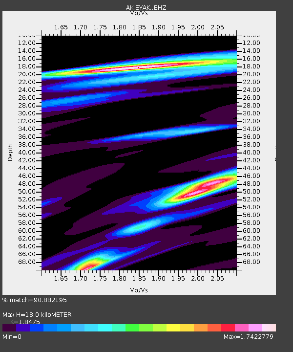
EYAK Cordova Ski Area - Earthquake Result Viewer
| Earthquake location: |
Santa Cruz Islands |
| Earthquake latitude/longitude: |
-10.4/165.2 |
| Earthquake time(UTC): |
2015/07/18 (199) 02:27:33 GMT |
| Earthquake Depth: |
10 km |
| Earthquake Magnitude: |
7.0 MWW, 7.5 MI |
| Earthquake Catalog/Contributor: |
NEIC PDE/NEIC COMCAT |
|
| Network: |
AK Alaska Regional Network |
| Station: |
EYAK Cordova Ski Area |
| Lat/Lon: |
60.55 N/145.75 W |
| Elevation: |
146 m |
|
| Distance: |
80.7 deg |
| Az: |
22.235 deg |
| Baz: |
228.869 deg |
| Ray Param: |
0.0481074 |
| Estimated Moho Depth: |
18.0 km |
| Estimated Crust Vp/Vs: |
1.85 |
| Assumed Crust Vp: |
6.566 km/s |
| Estimated Crust Vs: |
3.554 km/s |
| Estimated Crust Poisson's Ratio: |
0.29 |
|
| Radial Match: |
90.882195 % |
| Radial Bump: |
392 |
| Transverse Match: |
75.3313 % |
| Transverse Bump: |
400 |
| SOD ConfigId: |
7422571 |
| Insert Time: |
2019-04-19 21:13:37.292 +0000 |
| GWidth: |
2.5 |
| Max Bumps: |
400 |
| Tol: |
0.001 |
|

Signal To Noise
| Channel | StoN | STA | LTA |
| AK:EYAK: :BHZ:20150718T02:39:14.367974Z | 6.137481 | 2.144886E-6 | 3.494733E-7 |
| AK:EYAK: :BHN:20150718T02:39:14.367974Z | 1.8480756 | 7.423647E-7 | 4.0169607E-7 |
| AK:EYAK: :BHE:20150718T02:39:14.367974Z | 2.1953328 | 9.150007E-7 | 4.1679363E-7 |
| Arrivals |
| Ps | 2.4 SECOND |
| PpPs | 7.6 SECOND |
| PsPs/PpSs | 10.0 SECOND |


