You are here: Home > Network List > AK - Alaska Regional Network Stations List
> Station TRF Thorofare Mountian > Earthquake Result Viewer
TRF Thorofare Mountian - Earthquake Result Viewer
| Earthquake location: |
Santa Cruz Islands |
| Earthquake latitude/longitude: |
-10.4/165.2 |
| Earthquake time(UTC): |
2015/07/18 (199) 02:27:33 GMT |
| Earthquake Depth: |
10 km |
| Earthquake Magnitude: |
7.0 MWW, 7.5 MI |
| Earthquake Catalog/Contributor: |
NEIC PDE/NEIC COMCAT |
|
| Network: |
AK Alaska Regional Network |
| Station: |
TRF Thorofare Mountian |
| Lat/Lon: |
63.45 N/150.29 W |
| Elevation: |
1717 m |
|
| Distance: |
81.1 deg |
| Az: |
18.603 deg |
| Baz: |
224.291 deg |
| Ray Param: |
0.047801826 |
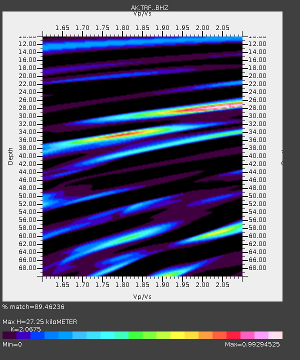
| Estimated Moho Depth: |
27.25 km |
| Estimated Crust Vp/Vs: |
2.07 |
| Assumed Crust Vp: |
6.438 km/s |
| Estimated Crust Vs: |
3.114 km/s |
| Estimated Crust Poisson's Ratio: |
0.35 |
|
| Radial Match: |
89.46236 % |
| Radial Bump: |
400 |
| Transverse Match: |
73.49314 % |
| Transverse Bump: |
400 |
| SOD ConfigId: |
7422571 |
| Insert Time: |
2019-04-19 21:14:21.295 +0000 |
| GWidth: |
2.5 |
| Max Bumps: |
400 |
| Tol: |
0.001 |
|

Signal To Noise
| Channel | StoN | STA | LTA |
| AK:TRF: :BHZ:20150718T02:39:16.708Z | 22.096634 | 3.3154292E-6 | 1.5004228E-7 |
| AK:TRF: :BHN:20150718T02:39:16.708Z | 5.661502 | 1.1397854E-6 | 2.0132208E-7 |
| AK:TRF: :BHE:20150718T02:39:16.708Z | 3.7444994 | 1.1161787E-6 | 2.980849E-7 |
| Arrivals |
| Ps | 4.6 SECOND |
| PpPs | 13 SECOND |
| PsPs/PpSs | 17 SECOND |


