You are here: Home > Network List > AV - Alaska Volcano Observatory Stations List
> Station SPNN North Nagishlamina, Mount Spurr, Alaska > Earthquake Result Viewer
SPNN North Nagishlamina, Mount Spurr, Alaska - Earthquake Result Viewer
| Earthquake location: |
Santa Cruz Islands |
| Earthquake latitude/longitude: |
-10.4/165.2 |
| Earthquake time(UTC): |
2015/07/18 (199) 02:27:33 GMT |
| Earthquake Depth: |
10 km |
| Earthquake Magnitude: |
7.0 MWW, 7.5 MI |
| Earthquake Catalog/Contributor: |
NEIC PDE/NEIC COMCAT |
|
| Network: |
AV Alaska Volcano Observatory |
| Station: |
SPNN North Nagishlamina, Mount Spurr, Alaska |
| Lat/Lon: |
61.37 N/152.70 W |
| Elevation: |
1666 m |
|
| Distance: |
78.8 deg |
| Az: |
19.229 deg |
| Baz: |
222.263 deg |
| Ray Param: |
0.049370356 |
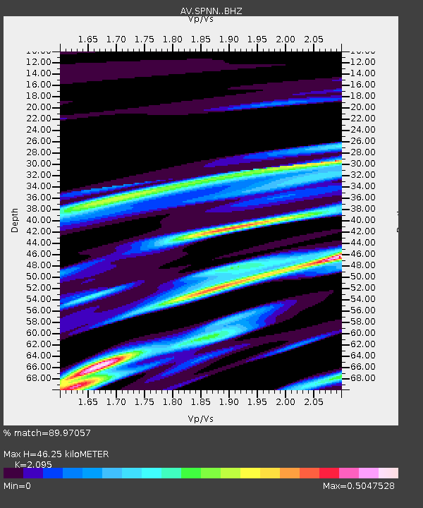
| Estimated Moho Depth: |
46.25 km |
| Estimated Crust Vp/Vs: |
2.10 |
| Assumed Crust Vp: |
6.566 km/s |
| Estimated Crust Vs: |
3.134 km/s |
| Estimated Crust Poisson's Ratio: |
0.35 |
|
| Radial Match: |
89.97057 % |
| Radial Bump: |
400 |
| Transverse Match: |
79.285286 % |
| Transverse Bump: |
400 |
| SOD ConfigId: |
7422571 |
| Insert Time: |
2019-04-19 21:15:05.073 +0000 |
| GWidth: |
2.5 |
| Max Bumps: |
400 |
| Tol: |
0.001 |
|

Signal To Noise
| Channel | StoN | STA | LTA |
| AV:SPNN: :BHZ:20150718T02:39:04.359978Z | 7.385517 | 2.4524556E-6 | 3.3206283E-7 |
| AV:SPNN: :BHN:20150718T02:39:04.359978Z | 3.0820067 | 7.908631E-7 | 2.5660657E-7 |
| AV:SPNN: :BHE:20150718T02:39:04.359978Z | 4.43737 | 6.364585E-7 | 1.4343146E-7 |
| Arrivals |
| Ps | 7.9 SECOND |
| PpPs | 21 SECOND |
| PsPs/PpSs | 29 SECOND |


