You are here: Home > Network List > CC - Cascade Chain Volcano Monitoring Stations List
> Station TMBU Tom Butte, Newberry, OR > Earthquake Result Viewer
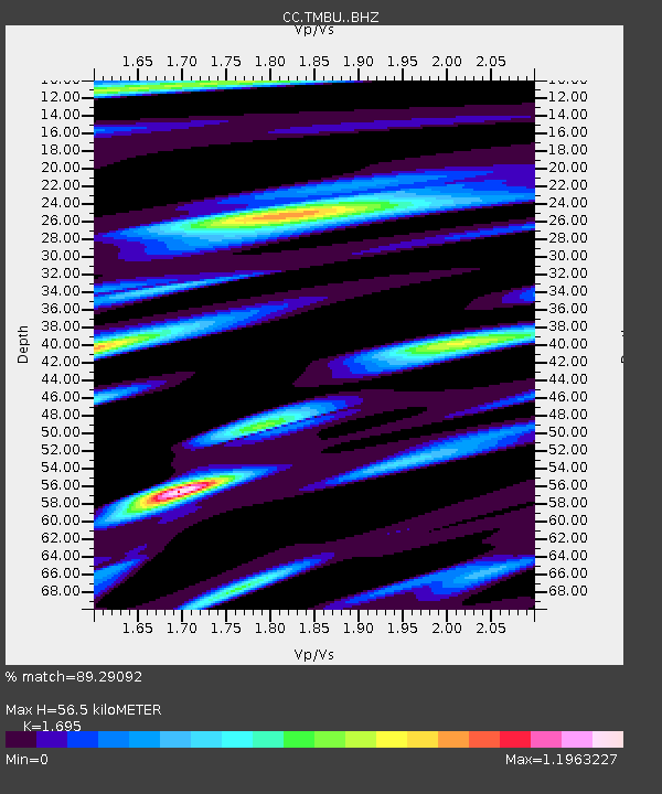
TMBU Tom Butte, Newberry, OR - Earthquake Result Viewer
| Earthquake location: |
Santa Cruz Islands |
| Earthquake latitude/longitude: |
-10.4/165.2 |
| Earthquake time(UTC): |
2015/07/18 (199) 02:27:33 GMT |
| Earthquake Depth: |
10 km |
| Earthquake Magnitude: |
7.0 MWW, 7.5 MI |
| Earthquake Catalog/Contributor: |
NEIC PDE/NEIC COMCAT |
|
| Network: |
CC Cascade Chain Volcano Monitoring |
| Station: |
TMBU Tom Butte, Newberry, OR |
| Lat/Lon: |
43.60 N/121.14 W |
| Elevation: |
1743 m |
|
| Distance: |
85.6 deg |
| Az: |
44.369 deg |
| Baz: |
251.235 deg |
| Ray Param: |
0.04465922 |
| Estimated Moho Depth: |
56.5 km |
| Estimated Crust Vp/Vs: |
1.70 |
| Assumed Crust Vp: |
6.597 km/s |
| Estimated Crust Vs: |
3.892 km/s |
| Estimated Crust Poisson's Ratio: |
0.23 |
|
| Radial Match: |
89.29092 % |
| Radial Bump: |
400 |
| Transverse Match: |
89.4439 % |
| Transverse Bump: |
400 |
| SOD ConfigId: |
7422571 |
| Insert Time: |
2019-04-19 21:15:46.884 +0000 |
| GWidth: |
2.5 |
| Max Bumps: |
400 |
| Tol: |
0.001 |
|

Signal To Noise
| Channel | StoN | STA | LTA |
| CC:TMBU: :BHZ:20150718T02:39:39.660027Z | 6.196762 | 1.5061628E-6 | 2.4305643E-7 |
| CC:TMBU: :BHN:20150718T02:39:39.660027Z | 0.82161874 | 2.958358E-7 | 3.6006458E-7 |
| CC:TMBU: :BHE:20150718T02:39:39.660027Z | 2.2163918 | 8.531512E-7 | 3.8492797E-7 |
| Arrivals |
| Ps | 6.1 SECOND |
| PpPs | 22 SECOND |
| PsPs/PpSs | 29 SECOND |


