You are here: Home > Network List > CN - Canadian National Seismograph Network Stations List
> Station LLLB Lillooet, BC, CA > Earthquake Result Viewer
LLLB Lillooet, BC, CA - Earthquake Result Viewer
| Earthquake location: |
Santa Cruz Islands |
| Earthquake latitude/longitude: |
-10.4/165.2 |
| Earthquake time(UTC): |
2015/07/18 (199) 02:27:33 GMT |
| Earthquake Depth: |
10 km |
| Earthquake Magnitude: |
7.0 MWW, 7.5 MI |
| Earthquake Catalog/Contributor: |
NEIC PDE/NEIC COMCAT |
|
| Network: |
CN Canadian National Seismograph Network |
| Station: |
LLLB Lillooet, BC, CA |
| Lat/Lon: |
50.61 N/121.88 W |
| Elevation: |
700 m |
|
| Distance: |
87.4 deg |
| Az: |
37.572 deg |
| Baz: |
250.28 deg |
| Ray Param: |
0.043337077 |
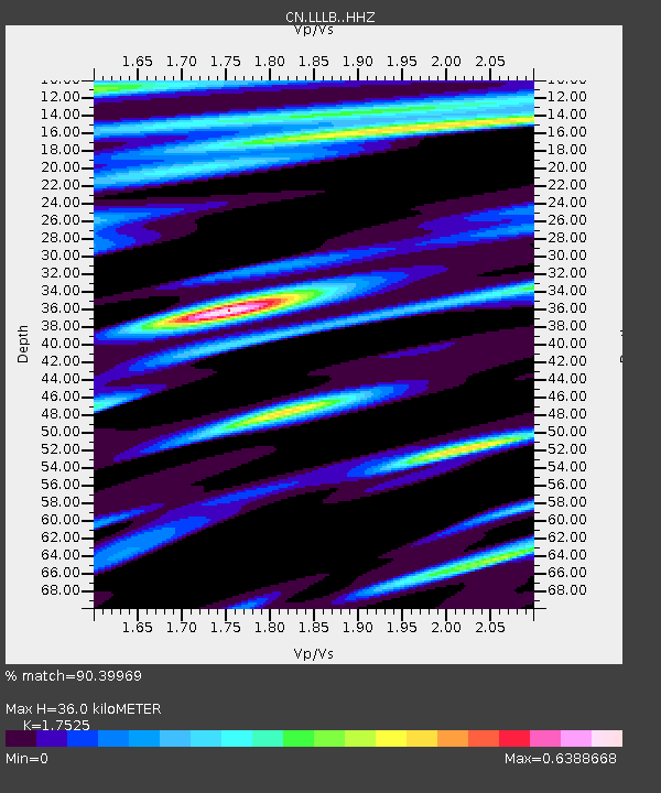
| Estimated Moho Depth: |
36.0 km |
| Estimated Crust Vp/Vs: |
1.75 |
| Assumed Crust Vp: |
6.597 km/s |
| Estimated Crust Vs: |
3.765 km/s |
| Estimated Crust Poisson's Ratio: |
0.26 |
|
| Radial Match: |
90.39969 % |
| Radial Bump: |
400 |
| Transverse Match: |
81.81519 % |
| Transverse Bump: |
400 |
| SOD ConfigId: |
7422571 |
| Insert Time: |
2019-04-19 21:16:51.290 +0000 |
| GWidth: |
2.5 |
| Max Bumps: |
400 |
| Tol: |
0.001 |
|
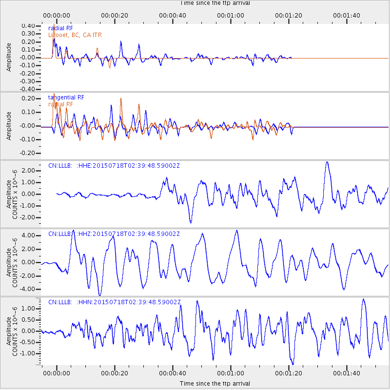
Signal To Noise
| Channel | StoN | STA | LTA |
| CN:LLLB: :HHZ:20150718T02:39:48.59002Z | 6.5943527 | 9.705184E-7 | 1.4717416E-7 |
| CN:LLLB: :HHN:20150718T02:39:48.59002Z | 0.86517 | 1.2219246E-7 | 1.412352E-7 |
| CN:LLLB: :HHE:20150718T02:39:48.59002Z | 1.8818438 | 2.0451323E-7 | 1.0867705E-7 |
| Arrivals |
| Ps | 4.2 SECOND |
| PpPs | 15 SECOND |
| PsPs/PpSs | 19 SECOND |


