You are here: Home > Network List > WY - Yellowstone Wyoming Seismic Network Stations List
> Station YHL Hebgen Lake, YNP, WY, USA > Earthquake Result Viewer
YHL Hebgen Lake, YNP, WY, USA - Earthquake Result Viewer
| Earthquake location: |
Northern Colombia |
| Earthquake latitude/longitude: |
6.8/-73.0 |
| Earthquake time(UTC): |
2015/03/10 (069) 20:55:43 GMT |
| Earthquake Depth: |
147 km |
| Earthquake Magnitude: |
6.2 MWB |
| Earthquake Catalog/Contributor: |
NEIC PDE/NEIC COMCAT |
|
| Network: |
WY Yellowstone Wyoming Seismic Network |
| Station: |
YHL Hebgen Lake, YNP, WY, USA |
| Lat/Lon: |
44.85 N/111.18 W |
| Elevation: |
2691 m |
|
| Distance: |
50.3 deg |
| Az: |
325.176 deg |
| Baz: |
127.135 deg |
| Ray Param: |
0.06761319 |
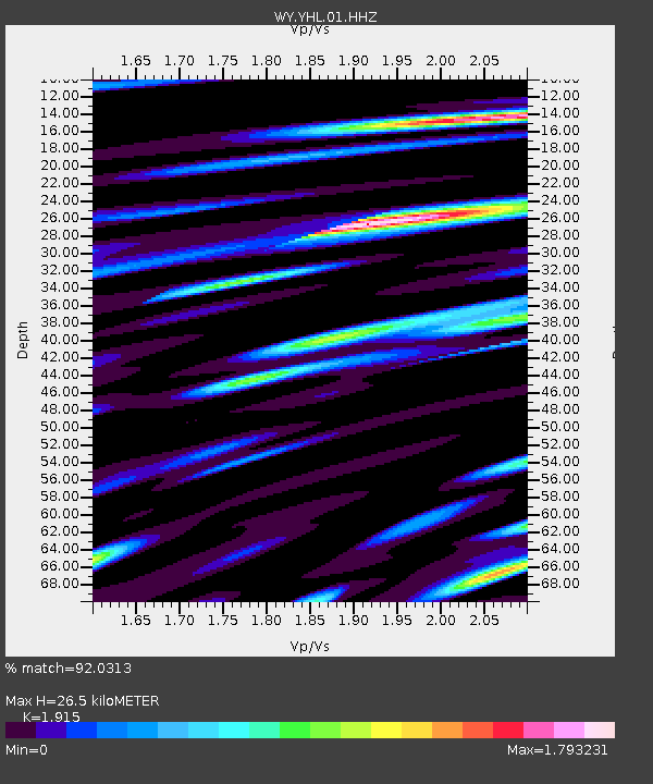
| Estimated Moho Depth: |
26.5 km |
| Estimated Crust Vp/Vs: |
1.91 |
| Assumed Crust Vp: |
6.35 km/s |
| Estimated Crust Vs: |
3.316 km/s |
| Estimated Crust Poisson's Ratio: |
0.31 |
|
| Radial Match: |
92.0313 % |
| Radial Bump: |
400 |
| Transverse Match: |
89.28858 % |
| Transverse Bump: |
400 |
| SOD ConfigId: |
872571 |
| Insert Time: |
2015-03-24 21:22:54.950 +0000 |
| GWidth: |
2.5 |
| Max Bumps: |
400 |
| Tol: |
0.001 |
|

Signal To Noise
| Channel | StoN | STA | LTA |
| WY:YHL:01:HHZ:20150310T21:03:54.518007Z | 22.167728 | 9.027956E-8 | 4.072567E-9 |
| WY:YHL:01:HHN:20150310T21:03:54.518007Z | 9.60398 | 3.4045296E-8 | 3.5449155E-9 |
| WY:YHL:01:HHE:20150310T21:03:54.518007Z | 12.083553 | 4.001138E-8 | 3.3112262E-9 |
| Arrivals |
| Ps | 4.0 SECOND |
| PpPs | 12 SECOND |
| PsPs/PpSs | 16 SECOND |


