You are here: Home > Network List > NY - Yukon Northwest Seismic Network(YNSN) Stations List
> Station MMPY Sheldon Lake, Yukon, CANADA > Earthquake Result Viewer
MMPY Sheldon Lake, Yukon, CANADA - Earthquake Result Viewer
| Earthquake location: |
Santa Cruz Islands |
| Earthquake latitude/longitude: |
-10.4/165.2 |
| Earthquake time(UTC): |
2015/07/18 (199) 02:27:33 GMT |
| Earthquake Depth: |
10 km |
| Earthquake Magnitude: |
7.0 MWW, 7.5 MI |
| Earthquake Catalog/Contributor: |
NEIC PDE/NEIC COMCAT |
|
| Network: |
NY Yukon Northwest Seismic Network(YNSN) |
| Station: |
MMPY Sheldon Lake, Yukon, CANADA |
| Lat/Lon: |
62.62 N/131.26 W |
| Elevation: |
0.0 m |
|
| Distance: |
87.5 deg |
| Az: |
24.481 deg |
| Baz: |
241.838 deg |
| Ray Param: |
0.043247502 |
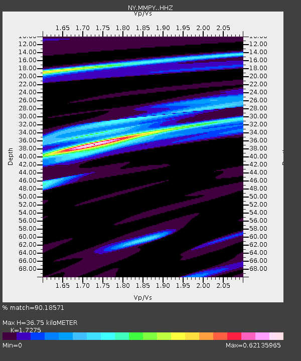
| Estimated Moho Depth: |
36.75 km |
| Estimated Crust Vp/Vs: |
1.73 |
| Assumed Crust Vp: |
6.419 km/s |
| Estimated Crust Vs: |
3.716 km/s |
| Estimated Crust Poisson's Ratio: |
0.25 |
|
| Radial Match: |
90.18571 % |
| Radial Bump: |
317 |
| Transverse Match: |
82.397675 % |
| Transverse Bump: |
400 |
| SOD ConfigId: |
7422571 |
| Insert Time: |
2019-04-19 21:18:22.823 +0000 |
| GWidth: |
2.5 |
| Max Bumps: |
400 |
| Tol: |
0.001 |
|

Signal To Noise
| Channel | StoN | STA | LTA |
| NY:MMPY: :HHZ:20150718T02:39:49.150017Z | 7.7886105 | 1.4372556E-6 | 1.84533E-7 |
| NY:MMPY: :HHN:20150718T02:39:49.150017Z | 2.0395517 | 1.3635497E-7 | 6.6855364E-8 |
| NY:MMPY: :HHE:20150718T02:39:49.150017Z | 2.894271 | 4.8672615E-7 | 1.6816882E-7 |
| Arrivals |
| Ps | 4.3 SECOND |
| PpPs | 15 SECOND |
| PsPs/PpSs | 20 SECOND |


