You are here: Home > Network List > PB - Plate Boundary Observatory Borehole Seismic Network Stations List
> Station B082 pathfi082bcs2006, Anza, CA, USA > Earthquake Result Viewer
B082 pathfi082bcs2006, Anza, CA, USA - Earthquake Result Viewer
| Earthquake location: |
Santa Cruz Islands |
| Earthquake latitude/longitude: |
-10.4/165.2 |
| Earthquake time(UTC): |
2015/07/18 (199) 02:27:33 GMT |
| Earthquake Depth: |
10 km |
| Earthquake Magnitude: |
7.0 MWW, 7.5 MI |
| Earthquake Catalog/Contributor: |
NEIC PDE/NEIC COMCAT |
|
| Network: |
PB Plate Boundary Observatory Borehole Seismic Network |
| Station: |
B082 pathfi082bcs2006, Anza, CA, USA |
| Lat/Lon: |
33.60 N/116.60 W |
| Elevation: |
1375 m |
|
| Distance: |
86.1 deg |
| Az: |
54.986 deg |
| Baz: |
254.846 deg |
| Ray Param: |
0.04430106 |
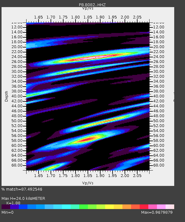
| Estimated Moho Depth: |
24.0 km |
| Estimated Crust Vp/Vs: |
1.88 |
| Assumed Crust Vp: |
6.264 km/s |
| Estimated Crust Vs: |
3.332 km/s |
| Estimated Crust Poisson's Ratio: |
0.30 |
|
| Radial Match: |
87.492546 % |
| Radial Bump: |
400 |
| Transverse Match: |
83.05542 % |
| Transverse Bump: |
400 |
| SOD ConfigId: |
7422571 |
| Insert Time: |
2019-04-19 21:18:26.521 +0000 |
| GWidth: |
2.5 |
| Max Bumps: |
400 |
| Tol: |
0.001 |
|

Signal To Noise
| Channel | StoN | STA | LTA |
| PB:B082: :HHZ:20150718T02:39:42.158989Z | 5.0598326 | 1.2784186E-8 | 2.5266027E-9 |
| PB:B082: :HH1:20150718T02:39:42.158989Z | 1.2413036 | 3.003303E-9 | 2.419475E-9 |
| PB:B082: :HH2:20150718T02:39:42.158989Z | 1.13824 | 2.3484594E-9 | 2.0632376E-9 |
| Arrivals |
| Ps | 3.4 SECOND |
| PpPs | 11 SECOND |
| PsPs/PpSs | 14 SECOND |


