You are here: Home > Network List > S - Seismographs in Schools Projects Stations List
> Station AULHS Lilydale High School, Lilydale, TAS > Earthquake Result Viewer
AULHS Lilydale High School, Lilydale, TAS - Earthquake Result Viewer
| Earthquake location: |
Santa Cruz Islands |
| Earthquake latitude/longitude: |
-10.4/165.2 |
| Earthquake time(UTC): |
2015/07/18 (199) 02:27:33 GMT |
| Earthquake Depth: |
10 km |
| Earthquake Magnitude: |
7.0 MWW, 7.5 MI |
| Earthquake Catalog/Contributor: |
NEIC PDE/NEIC COMCAT |
|
| Network: |
S Seismographs in Schools Projects |
| Station: |
AULHS Lilydale High School, Lilydale, TAS |
| Lat/Lon: |
41.25 S/147.21 E |
| Elevation: |
173 m |
|
| Distance: |
34.5 deg |
| Az: |
204.212 deg |
| Baz: |
32.345 deg |
| Ray Param: |
0.077695206 |
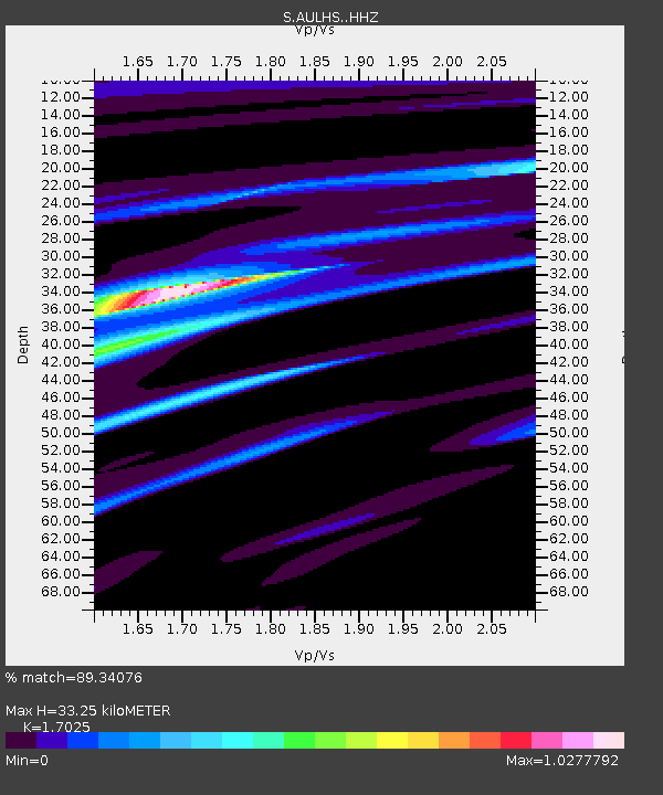
| Estimated Moho Depth: |
33.25 km |
| Estimated Crust Vp/Vs: |
1.70 |
| Assumed Crust Vp: |
6.39 km/s |
| Estimated Crust Vs: |
3.753 km/s |
| Estimated Crust Poisson's Ratio: |
0.24 |
|
| Radial Match: |
89.34076 % |
| Radial Bump: |
398 |
| Transverse Match: |
67.020584 % |
| Transverse Bump: |
400 |
| SOD ConfigId: |
7422571 |
| Insert Time: |
2019-04-19 21:18:53.305 +0000 |
| GWidth: |
2.5 |
| Max Bumps: |
400 |
| Tol: |
0.001 |
|

Signal To Noise
| Channel | StoN | STA | LTA |
| S:AULHS: :HHZ:20150718T02:33:49.749993Z | 3.8973513 | 3.0433987E-6 | 7.8088897E-7 |
| S:AULHS: :HHN:20150718T02:33:49.749993Z | 1.1225526 | 1.9805002E-6 | 1.7642826E-6 |
| S:AULHS: :HHE:20150718T02:33:49.749993Z | 3.2695484 | 2.8988716E-6 | 8.866275E-7 |
| Arrivals |
| Ps | 4.0 SECOND |
| PpPs | 13 SECOND |
| PsPs/PpSs | 17 SECOND |


