You are here: Home > Network List > TA - USArray Transportable Network (new EarthScope stations) Stations List
> Station I03D Drain, OR, USA > Earthquake Result Viewer
I03D Drain, OR, USA - Earthquake Result Viewer

| Earthquake location: |
Santa Cruz Islands |
| Earthquake latitude/longitude: |
-10.4/165.2 |
| Earthquake time(UTC): |
2015/07/18 (199) 02:27:33 GMT |
| Earthquake Depth: |
10 km |
| Earthquake Magnitude: |
7.0 MWW, 7.5 MI |
| Earthquake Catalog/Contributor: |
NEIC PDE/NEIC COMCAT |
|
| Network: |
TA USArray Transportable Network (new EarthScope stations) |
| Station: |
I03D Drain, OR, USA |
| Lat/Lon: |
43.70 N/123.35 W |
| Elevation: |
140 m |
|
| Distance: |
84.1 deg |
| Az: |
43.741 deg |
| Baz: |
249.662 deg |
| Ray Param: |
0.045713343 |
| Estimated Moho Depth: |
45.0 km |
| Estimated Crust Vp/Vs: |
1.78 |
| Assumed Crust Vp: |
6.522 km/s |
| Estimated Crust Vs: |
3.664 km/s |
| Estimated Crust Poisson's Ratio: |
0.27 |
|
| Radial Match: |
90.57183 % |
| Radial Bump: |
383 |
| Transverse Match: |
80.35641 % |
| Transverse Bump: |
400 |
| SOD ConfigId: |
7422571 |
| Insert Time: |
2019-04-19 21:19:15.803 +0000 |
| GWidth: |
2.5 |
| Max Bumps: |
400 |
| Tol: |
0.001 |
|
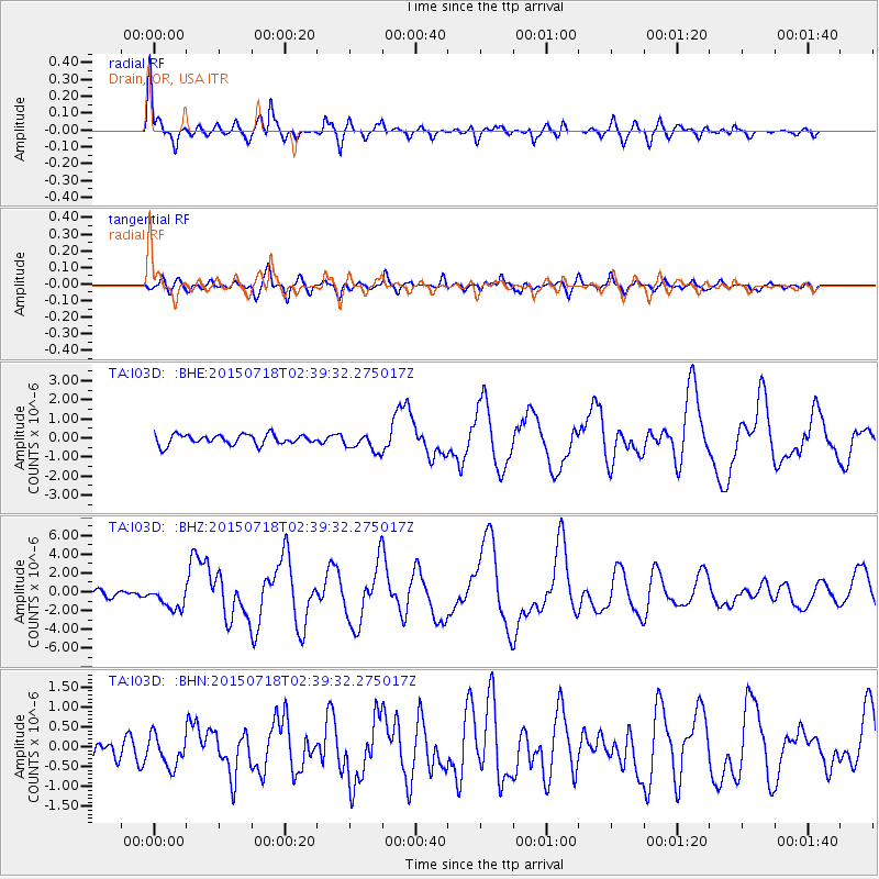
Signal To Noise
| Channel | StoN | STA | LTA |
| TA:I03D: :BHZ:20150718T02:39:32.275017Z | 3.4888768 | 1.2241284E-6 | 3.5086603E-7 |
| TA:I03D: :BHN:20150718T02:39:32.275017Z | 1.4235021 | 4.038203E-7 | 2.8368086E-7 |
| TA:I03D: :BHE:20150718T02:39:32.275017Z | 1.9081525 | 4.994924E-7 | 2.6176755E-7 |
| Arrivals |
| Ps | 5.5 SECOND |
| PpPs | 19 SECOND |
| PsPs/PpSs | 24 SECOND |


