You are here: Home > Network List > TA - USArray Transportable Network (new EarthScope stations) Stations List
> Station L19K White Mountain, AK, USA > Earthquake Result Viewer
L19K White Mountain, AK, USA - Earthquake Result Viewer

| Earthquake location: |
Santa Cruz Islands |
| Earthquake latitude/longitude: |
-10.4/165.2 |
| Earthquake time(UTC): |
2015/07/18 (199) 02:27:33 GMT |
| Earthquake Depth: |
10 km |
| Earthquake Magnitude: |
7.0 MWW, 7.5 MI |
| Earthquake Catalog/Contributor: |
NEIC PDE/NEIC COMCAT |
|
| Network: |
TA USArray Transportable Network (new EarthScope stations) |
| Station: |
L19K White Mountain, AK, USA |
| Lat/Lon: |
62.18 N/154.85 W |
| Elevation: |
650 m |
|
| Distance: |
78.8 deg |
| Az: |
17.894 deg |
| Baz: |
220.11 deg |
| Ray Param: |
0.049409706 |
| Estimated Moho Depth: |
69.75 km |
| Estimated Crust Vp/Vs: |
1.76 |
| Assumed Crust Vp: |
6.438 km/s |
| Estimated Crust Vs: |
3.653 km/s |
| Estimated Crust Poisson's Ratio: |
0.26 |
|
| Radial Match: |
95.42641 % |
| Radial Bump: |
380 |
| Transverse Match: |
86.06593 % |
| Transverse Bump: |
400 |
| SOD ConfigId: |
7422571 |
| Insert Time: |
2019-04-19 21:19:28.984 +0000 |
| GWidth: |
2.5 |
| Max Bumps: |
400 |
| Tol: |
0.001 |
|
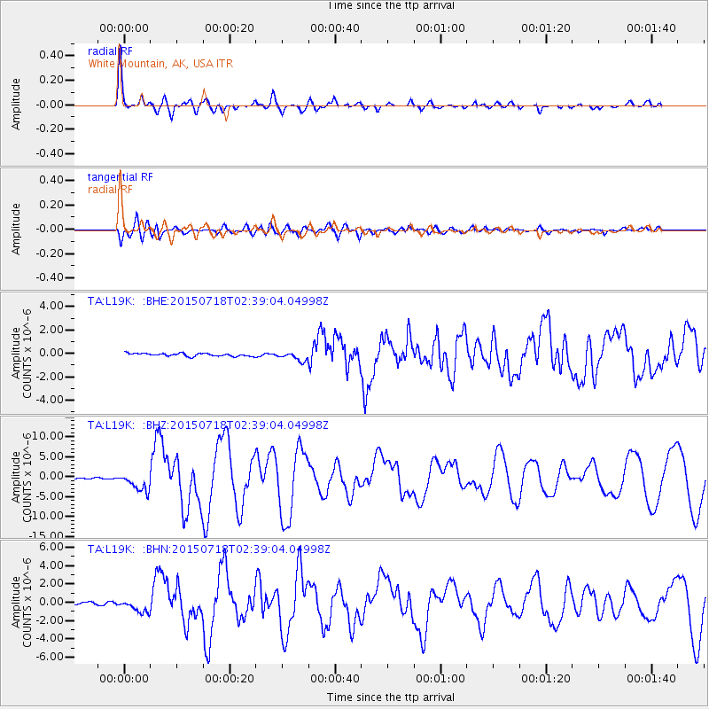
Signal To Noise
| Channel | StoN | STA | LTA |
| TA:L19K: :BHZ:20150718T02:39:04.04998Z | 14.958226 | 2.2882987E-6 | 1.5297928E-7 |
| TA:L19K: :BHN:20150718T02:39:04.04998Z | 6.012161 | 7.590344E-7 | 1.2624984E-7 |
| TA:L19K: :BHE:20150718T02:39:04.04998Z | 4.412133 | 5.2746066E-7 | 1.1954776E-7 |
| Arrivals |
| Ps | 8.5 SECOND |
| PpPs | 29 SECOND |
| PsPs/PpSs | 38 SECOND |


