You are here: Home > Network List > TW - Broadband Array in Taiwan for Seismology Stations List
> Station VNAS Nansha Is. > Earthquake Result Viewer
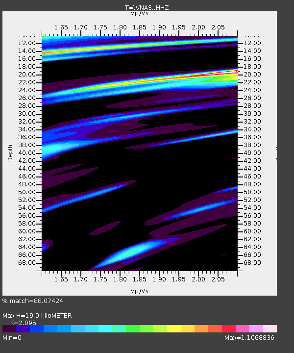
VNAS Nansha Is. - Earthquake Result Viewer
| Earthquake location: |
Santa Cruz Islands |
| Earthquake latitude/longitude: |
-10.4/165.2 |
| Earthquake time(UTC): |
2015/07/18 (199) 02:27:33 GMT |
| Earthquake Depth: |
10 km |
| Earthquake Magnitude: |
7.0 MWW, 7.5 MI |
| Earthquake Catalog/Contributor: |
NEIC PDE/NEIC COMCAT |
|
| Network: |
TW Broadband Array in Taiwan for Seismology |
| Station: |
VNAS Nansha Is. |
| Lat/Lon: |
10.38 N/114.36 E |
| Elevation: |
2.0 m |
|
| Distance: |
54.6 deg |
| Az: |
290.692 deg |
| Baz: |
110.724 deg |
| Ray Param: |
0.06534954 |
| Estimated Moho Depth: |
19.0 km |
| Estimated Crust Vp/Vs: |
2.10 |
| Assumed Crust Vp: |
6.183 km/s |
| Estimated Crust Vs: |
2.951 km/s |
| Estimated Crust Poisson's Ratio: |
0.35 |
|
| Radial Match: |
88.07424 % |
| Radial Bump: |
282 |
| Transverse Match: |
83.89894 % |
| Transverse Bump: |
397 |
| SOD ConfigId: |
7422571 |
| Insert Time: |
2019-04-19 21:20:23.158 +0000 |
| GWidth: |
2.5 |
| Max Bumps: |
400 |
| Tol: |
0.001 |
|

Signal To Noise
| Channel | StoN | STA | LTA |
| TW:VNAS: :HHZ:20150718T02:36:29.489983Z | 5.5949965 | 1.0111935E-5 | 1.8073175E-6 |
| TW:VNAS: :HHN:20150718T02:36:29.489983Z | 1.4038123 | 3.0273902E-6 | 2.1565493E-6 |
| TW:VNAS: :HHE:20150718T02:36:29.489983Z | 3.420103 | 5.966557E-6 | 1.7445549E-6 |
| Arrivals |
| Ps | 3.5 SECOND |
| PpPs | 9.1 SECOND |
| PsPs/PpSs | 13 SECOND |


