You are here: Home > Network List > US - United States National Seismic Network Stations List
> Station DGMT Dagmar, Montana, USA > Earthquake Result Viewer
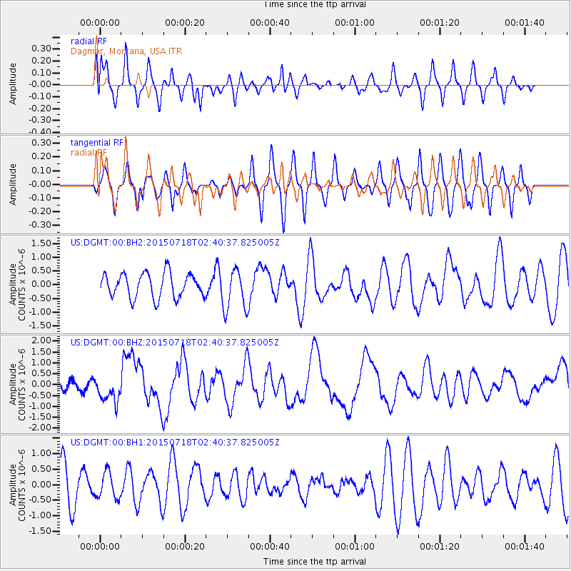
DGMT Dagmar, Montana, USA - Earthquake Result Viewer
*The percent match for this event was below the threshold and hence no stack was calculated.
| Earthquake location: |
Santa Cruz Islands |
| Earthquake latitude/longitude: |
-10.4/165.2 |
| Earthquake time(UTC): |
2015/07/18 (199) 02:27:33 GMT |
| Earthquake Depth: |
10 km |
| Earthquake Magnitude: |
7.0 MWW, 7.5 MI |
| Earthquake Catalog/Contributor: |
NEIC PDE/NEIC COMCAT |
|
| Network: |
US United States National Seismic Network |
| Station: |
DGMT Dagmar, Montana, USA |
| Lat/Lon: |
48.47 N/104.20 W |
| Elevation: |
0.0 m |
|
| Distance: |
98.1 deg |
| Az: |
42.24 deg |
| Baz: |
263.519 deg |
| Ray Param: |
$rayparam |
*The percent match for this event was below the threshold and hence was not used in the summary stack. |
|
| Radial Match: |
44.637848 % |
| Radial Bump: |
400 |
| Transverse Match: |
56.414494 % |
| Transverse Bump: |
400 |
| SOD ConfigId: |
7422571 |
| Insert Time: |
2019-04-19 21:20:26.432 +0000 |
| GWidth: |
2.5 |
| Max Bumps: |
400 |
| Tol: |
0.001 |
|
Signal To Noise
| Channel | StoN | STA | LTA |
| US:DGMT:00:BHZ:20150718T02:40:37.825005Z | 3.4544115 | 5.8165165E-7 | 1.6837939E-7 |
| US:DGMT:00:BH1:20150718T02:40:37.825005Z | 0.7404352 | 4.200057E-7 | 5.672417E-7 |
| US:DGMT:00:BH2:20150718T02:40:37.825005Z | 1.5104548 | 6.684158E-7 | 4.425262E-7 |
| Arrivals |
| Ps | |
| PpPs | |
| PsPs/PpSs | |


