You are here: Home > Network List > UW - Pacific Northwest Regional Seismic Network Stations List
> Station LON Longmire CREST broad-band > Earthquake Result Viewer
LON Longmire CREST broad-band - Earthquake Result Viewer
| Earthquake location: |
Santa Cruz Islands |
| Earthquake latitude/longitude: |
-10.4/165.2 |
| Earthquake time(UTC): |
2015/07/18 (199) 02:27:33 GMT |
| Earthquake Depth: |
10 km |
| Earthquake Magnitude: |
7.0 MWW, 7.5 MI |
| Earthquake Catalog/Contributor: |
NEIC PDE/NEIC COMCAT |
|
| Network: |
UW Pacific Northwest Regional Seismic Network |
| Station: |
LON Longmire CREST broad-band |
| Lat/Lon: |
46.75 N/121.81 W |
| Elevation: |
853 m |
|
| Distance: |
86.2 deg |
| Az: |
41.232 deg |
| Baz: |
250.539 deg |
| Ray Param: |
0.044241358 |
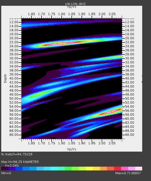
| Estimated Moho Depth: |
56.25 km |
| Estimated Crust Vp/Vs: |
2.05 |
| Assumed Crust Vp: |
6.597 km/s |
| Estimated Crust Vs: |
3.226 km/s |
| Estimated Crust Poisson's Ratio: |
0.34 |
|
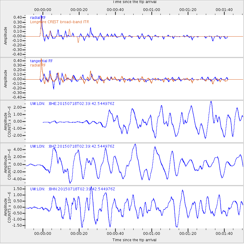
| Radial Match: |
94.75329 % |
| Radial Bump: |
400 |
| Transverse Match: |
91.188095 % |
| Transverse Bump: |
400 |
| SOD ConfigId: |
7422571 |
| Insert Time: |
2019-04-19 21:20:44.995 +0000 |
| GWidth: |
2.5 |
| Max Bumps: |
400 |
| Tol: |
0.001 |
|
Signal To Noise
| Channel | StoN | STA | LTA |
| UW:LON: :BHZ:20150718T02:39:42.544976Z | 8.676887 | 1.1518079E-6 | 1.3274438E-7 |
| UW:LON: :BHN:20150718T02:39:42.544976Z | 1.3888915 | 1.4388158E-7 | 1.03594544E-7 |
| UW:LON: :BHE:20150718T02:39:42.544976Z | 6.008416 | 4.3598578E-7 | 7.2562514E-8 |
| Arrivals |
| Ps | 9.1 SECOND |
| PpPs | 25 SECOND |
| PsPs/PpSs | 35 SECOND |


