You are here: Home > Network List > XD14 - Illuminating the architecture of the greater Mount St. Helens magmatic systems f Stations List
> Station MA05 "Mount St Helens, WA" > Earthquake Result Viewer
MA05 "Mount St Helens, WA" - Earthquake Result Viewer
| Earthquake location: |
Santa Cruz Islands |
| Earthquake latitude/longitude: |
-10.4/165.2 |
| Earthquake time(UTC): |
2015/07/18 (199) 02:27:33 GMT |
| Earthquake Depth: |
10 km |
| Earthquake Magnitude: |
7.0 MWW, 7.5 MI |
| Earthquake Catalog/Contributor: |
NEIC PDE/NEIC COMCAT |
|
| Network: |
XD Illuminating the architecture of the greater Mount St. Helens magmatic systems f |
| Station: |
MA05 "Mount St Helens, WA" |
| Lat/Lon: |
46.75 N/122.23 W |
| Elevation: |
488 m |
|
| Distance: |
85.9 deg |
| Az: |
41.131 deg |
| Baz: |
250.23 deg |
| Ray Param: |
0.044431806 |
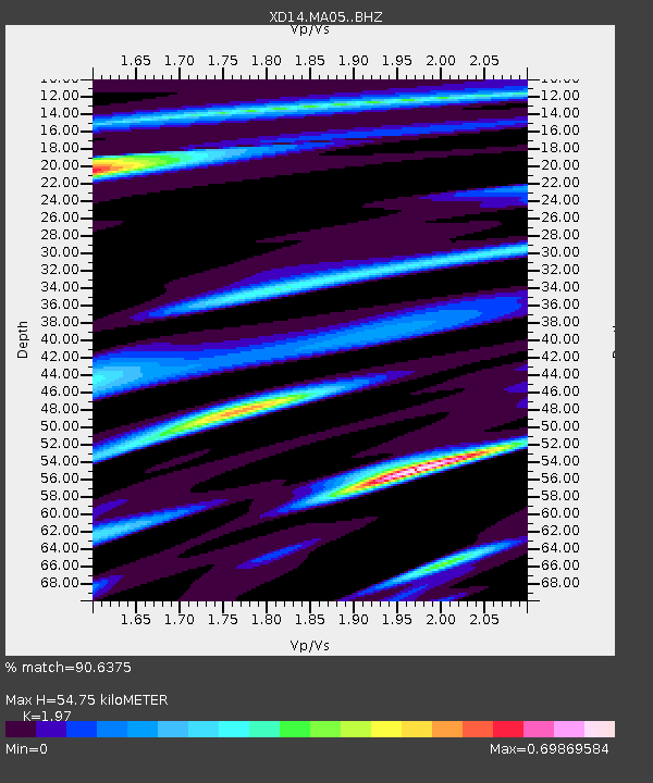
| Estimated Moho Depth: |
54.75 km |
| Estimated Crust Vp/Vs: |
1.97 |
| Assumed Crust Vp: |
6.566 km/s |
| Estimated Crust Vs: |
3.333 km/s |
| Estimated Crust Poisson's Ratio: |
0.33 |
|
| Radial Match: |
90.6375 % |
| Radial Bump: |
400 |
| Transverse Match: |
87.92155 % |
| Transverse Bump: |
400 |
| SOD ConfigId: |
7422571 |
| Insert Time: |
2019-04-19 21:21:00.182 +0000 |
| GWidth: |
2.5 |
| Max Bumps: |
400 |
| Tol: |
0.001 |
|

Signal To Noise
| Channel | StoN | STA | LTA |
| XD:MA05: :BHZ:20150718T02:39:41.210015Z | 7.2023125 | 1.3109777E-6 | 1.820218E-7 |
| XD:MA05: :BHN:20150718T02:39:41.210015Z | 1.9684323 | 4.139879E-7 | 2.103135E-7 |
| XD:MA05: :BHE:20150718T02:39:41.210015Z | 2.6522193 | 5.003513E-7 | 1.8865381E-7 |
| Arrivals |
| Ps | 8.3 SECOND |
| PpPs | 24 SECOND |
| PsPs/PpSs | 32 SECOND |


