You are here: Home > Network List > XD14 - Illuminating the architecture of the greater Mount St. Helens magmatic systems f Stations List
> Station MH11 "Mount St Helens, WA" > Earthquake Result Viewer
MH11 "Mount St Helens, WA" - Earthquake Result Viewer
| Earthquake location: |
Santa Cruz Islands |
| Earthquake latitude/longitude: |
-10.4/165.2 |
| Earthquake time(UTC): |
2015/07/18 (199) 02:27:33 GMT |
| Earthquake Depth: |
10 km |
| Earthquake Magnitude: |
7.0 MWW, 7.5 MI |
| Earthquake Catalog/Contributor: |
NEIC PDE/NEIC COMCAT |
|
| Network: |
XD Illuminating the architecture of the greater Mount St. Helens magmatic systems f |
| Station: |
MH11 "Mount St Helens, WA" |
| Lat/Lon: |
46.27 N/121.58 W |
| Elevation: |
1447 m |
|
| Distance: |
86.2 deg |
| Az: |
41.739 deg |
| Baz: |
250.74 deg |
| Ray Param: |
0.04424742 |
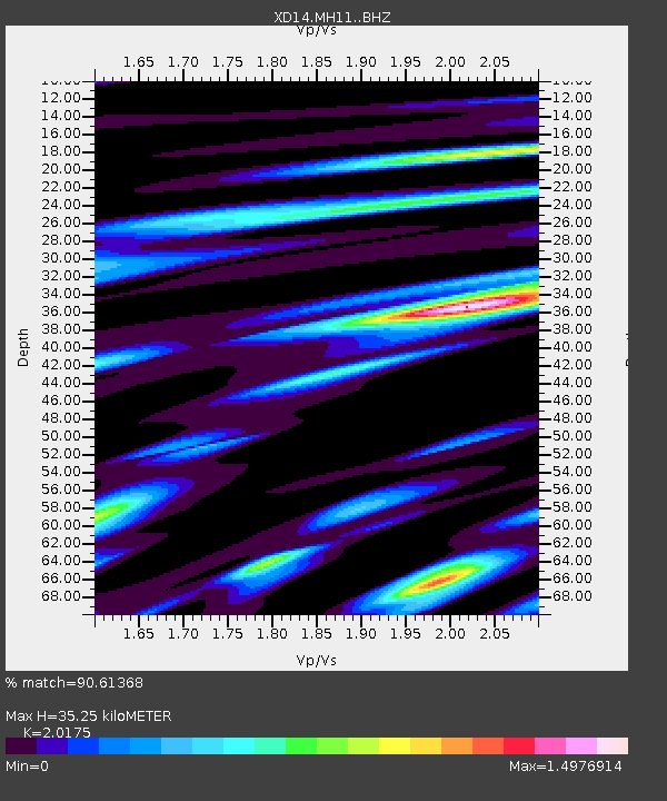
| Estimated Moho Depth: |
35.25 km |
| Estimated Crust Vp/Vs: |
2.02 |
| Assumed Crust Vp: |
6.597 km/s |
| Estimated Crust Vs: |
3.27 km/s |
| Estimated Crust Poisson's Ratio: |
0.34 |
|
| Radial Match: |
90.61368 % |
| Radial Bump: |
400 |
| Transverse Match: |
82.92426 % |
| Transverse Bump: |
400 |
| SOD ConfigId: |
7422571 |
| Insert Time: |
2019-04-19 21:21:20.438 +0000 |
| GWidth: |
2.5 |
| Max Bumps: |
400 |
| Tol: |
0.001 |
|

Signal To Noise
| Channel | StoN | STA | LTA |
| XD:MH11: :BHZ:20150718T02:39:42.499993Z | 7.633039 | 1.3795087E-6 | 1.8072863E-7 |
| XD:MH11: :BHN:20150718T02:39:42.499993Z | 1.4343023 | 2.8555246E-7 | 1.9908805E-7 |
| XD:MH11: :BHE:20150718T02:39:42.499993Z | 3.5028563 | 5.7190846E-7 | 1.6326918E-7 |
| Arrivals |
| Ps | 5.6 SECOND |
| PpPs | 16 SECOND |
| PsPs/PpSs | 21 SECOND |


