You are here: Home > Network List > XD14 - Illuminating the architecture of the greater Mount St. Helens magmatic systems f Stations List
> Station MI07 "Mount St Helens, WA" > Earthquake Result Viewer
MI07 "Mount St Helens, WA" - Earthquake Result Viewer
| Earthquake location: |
Santa Cruz Islands |
| Earthquake latitude/longitude: |
-10.4/165.2 |
| Earthquake time(UTC): |
2015/07/18 (199) 02:27:33 GMT |
| Earthquake Depth: |
10 km |
| Earthquake Magnitude: |
7.0 MWW, 7.5 MI |
| Earthquake Catalog/Contributor: |
NEIC PDE/NEIC COMCAT |
|
| Network: |
XD Illuminating the architecture of the greater Mount St. Helens magmatic systems f |
| Station: |
MI07 "Mount St Helens, WA" |
| Lat/Lon: |
46.25 N/122.07 W |
| Elevation: |
1124 m |
|
| Distance: |
85.8 deg |
| Az: |
41.645 deg |
| Baz: |
250.377 deg |
| Ray Param: |
0.044482388 |
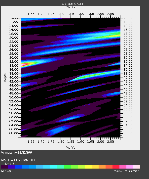
| Estimated Moho Depth: |
33.5 km |
| Estimated Crust Vp/Vs: |
1.60 |
| Assumed Crust Vp: |
6.566 km/s |
| Estimated Crust Vs: |
4.104 km/s |
| Estimated Crust Poisson's Ratio: |
0.18 |
|
| Radial Match: |
88.51599 % |
| Radial Bump: |
400 |
| Transverse Match: |
49.617413 % |
| Transverse Bump: |
400 |
| SOD ConfigId: |
7422571 |
| Insert Time: |
2019-04-19 21:21:23.648 +0000 |
| GWidth: |
2.5 |
| Max Bumps: |
400 |
| Tol: |
0.001 |
|

Signal To Noise
| Channel | StoN | STA | LTA |
| XD:MI07: :BHZ:20150718T02:39:40.864983Z | 6.9415116 | 1.2393419E-6 | 1.7854065E-7 |
| XD:MI07: :BHN:20150718T02:39:40.864983Z | 1.5324823 | 2.1663918E-6 | 1.4136489E-6 |
| XD:MI07: :BHE:20150718T02:39:40.864983Z | 1.1373818 | 3.205459E-7 | 2.8182788E-7 |
| Arrivals |
| Ps | 3.1 SECOND |
| PpPs | 13 SECOND |
| PsPs/PpSs | 16 SECOND |


