You are here: Home > Network List > XD14 - Illuminating the architecture of the greater Mount St. Helens magmatic systems f Stations List
> Station MJ07 "Mount St Helens, WA" > Earthquake Result Viewer
MJ07 "Mount St Helens, WA" - Earthquake Result Viewer
| Earthquake location: |
Santa Cruz Islands |
| Earthquake latitude/longitude: |
-10.4/165.2 |
| Earthquake time(UTC): |
2015/07/18 (199) 02:27:33 GMT |
| Earthquake Depth: |
10 km |
| Earthquake Magnitude: |
7.0 MWW, 7.5 MI |
| Earthquake Catalog/Contributor: |
NEIC PDE/NEIC COMCAT |
|
| Network: |
XD Illuminating the architecture of the greater Mount St. Helens magmatic systems f |
| Station: |
MJ07 "Mount St Helens, WA" |
| Lat/Lon: |
46.18 N/122.06 W |
| Elevation: |
509 m |
|
| Distance: |
85.8 deg |
| Az: |
41.715 deg |
| Baz: |
250.395 deg |
| Ray Param: |
0.04449081 |
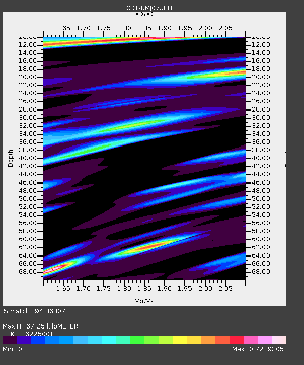
| Estimated Moho Depth: |
67.25 km |
| Estimated Crust Vp/Vs: |
1.62 |
| Assumed Crust Vp: |
6.566 km/s |
| Estimated Crust Vs: |
4.047 km/s |
| Estimated Crust Poisson's Ratio: |
0.19 |
|
| Radial Match: |
94.86807 % |
| Radial Bump: |
385 |
| Transverse Match: |
90.66958 % |
| Transverse Bump: |
400 |
| SOD ConfigId: |
7422571 |
| Insert Time: |
2019-04-19 21:21:29.685 +0000 |
| GWidth: |
2.5 |
| Max Bumps: |
400 |
| Tol: |
0.001 |
|

Signal To Noise
| Channel | StoN | STA | LTA |
| XD:MJ07: :BHZ:20150718T02:39:40.814995Z | 10.836718 | 1.1829001E-6 | 1.0915667E-7 |
| XD:MJ07: :BHN:20150718T02:39:40.814995Z | 1.908112 | 3.3336252E-7 | 1.7470805E-7 |
| XD:MJ07: :BHE:20150718T02:39:40.814995Z | 2.7351348 | 4.0679174E-7 | 1.4872822E-7 |
| Arrivals |
| Ps | 6.6 SECOND |
| PpPs | 26 SECOND |
| PsPs/PpSs | 33 SECOND |


