You are here: Home > Network List > XD14 - Illuminating the architecture of the greater Mount St. Helens magmatic systems f Stations List
> Station MM04 "Mount St Helens, WA" > Earthquake Result Viewer
MM04 "Mount St Helens, WA" - Earthquake Result Viewer
| Earthquake location: |
Santa Cruz Islands |
| Earthquake latitude/longitude: |
-10.4/165.2 |
| Earthquake time(UTC): |
2015/07/18 (199) 02:27:33 GMT |
| Earthquake Depth: |
10 km |
| Earthquake Magnitude: |
7.0 MWW, 7.5 MI |
| Earthquake Catalog/Contributor: |
NEIC PDE/NEIC COMCAT |
|
| Network: |
XD Illuminating the architecture of the greater Mount St. Helens magmatic systems f |
| Station: |
MM04 "Mount St Helens, WA" |
| Lat/Lon: |
46.02 N/122.35 W |
| Elevation: |
313 m |
|
| Distance: |
85.6 deg |
| Az: |
41.801 deg |
| Baz: |
250.193 deg |
| Ray Param: |
0.044666346 |
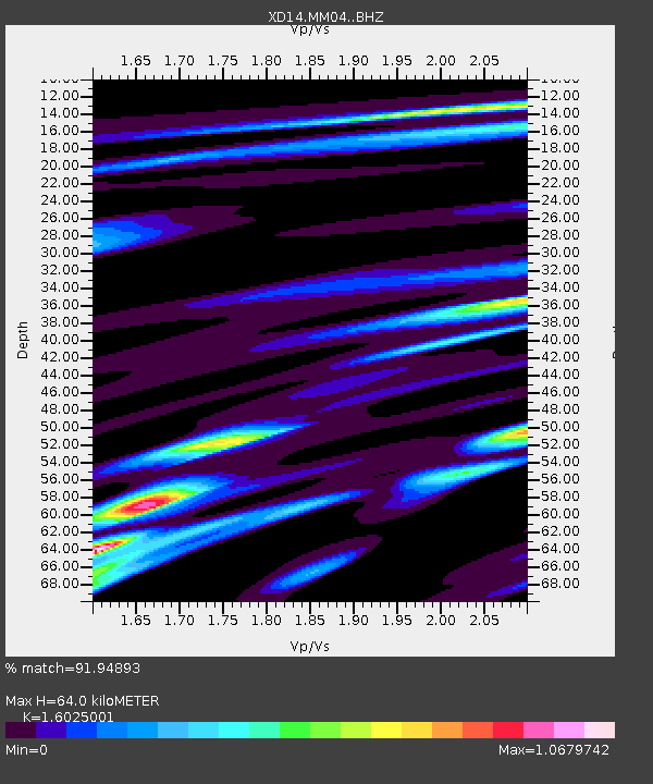
| Estimated Moho Depth: |
64.0 km |
| Estimated Crust Vp/Vs: |
1.60 |
| Assumed Crust Vp: |
6.566 km/s |
| Estimated Crust Vs: |
4.097 km/s |
| Estimated Crust Poisson's Ratio: |
0.18 |
|
| Radial Match: |
91.94893 % |
| Radial Bump: |
400 |
| Transverse Match: |
83.69783 % |
| Transverse Bump: |
400 |
| SOD ConfigId: |
7422571 |
| Insert Time: |
2019-04-19 21:21:38.671 +0000 |
| GWidth: |
2.5 |
| Max Bumps: |
400 |
| Tol: |
0.001 |
|

Signal To Noise
| Channel | StoN | STA | LTA |
| XD:MM04: :BHZ:20150718T02:39:39.604973Z | 9.007835 | 1.391933E-6 | 1.545247E-7 |
| XD:MM04: :BHN:20150718T02:39:39.604973Z | 2.0389984 | 3.0677808E-7 | 1.5045528E-7 |
| XD:MM04: :BHE:20150718T02:39:39.604973Z | 2.9294417 | 5.2719895E-7 | 1.7996567E-7 |
| Arrivals |
| Ps | 6.0 SECOND |
| PpPs | 25 SECOND |
| PsPs/PpSs | 31 SECOND |


