You are here: Home > Network List > ZJ12 - Transantarctic Mountains Northern Network Stations List
> Station DUBY Mt Kring, Antarctica > Earthquake Result Viewer
DUBY Mt Kring, Antarctica - Earthquake Result Viewer
| Earthquake location: |
Santa Cruz Islands |
| Earthquake latitude/longitude: |
-10.4/165.2 |
| Earthquake time(UTC): |
2015/07/18 (199) 02:27:33 GMT |
| Earthquake Depth: |
10 km |
| Earthquake Magnitude: |
7.0 MWW, 7.5 MI |
| Earthquake Catalog/Contributor: |
NEIC PDE/NEIC COMCAT |
|
| Network: |
ZJ Transantarctic Mountains Northern Network |
| Station: |
DUBY Mt Kring, Antarctica |
| Lat/Lon: |
74.99 S/158.08 E |
| Elevation: |
1508 m |
|
| Distance: |
64.6 deg |
| Az: |
182.042 deg |
| Baz: |
7.726 deg |
| Ray Param: |
0.05879387 |
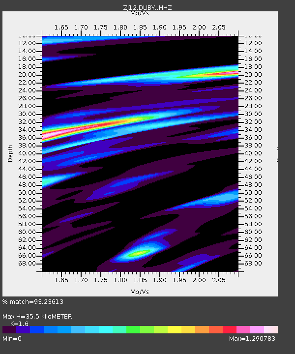
| Estimated Moho Depth: |
35.5 km |
| Estimated Crust Vp/Vs: |
1.60 |
| Assumed Crust Vp: |
6.182 km/s |
| Estimated Crust Vs: |
3.863 km/s |
| Estimated Crust Poisson's Ratio: |
0.18 |
|
| Radial Match: |
93.23613 % |
| Radial Bump: |
400 |
| Transverse Match: |
83.93872 % |
| Transverse Bump: |
400 |
| SOD ConfigId: |
7422571 |
| Insert Time: |
2019-04-19 21:23:28.308 +0000 |
| GWidth: |
2.5 |
| Max Bumps: |
400 |
| Tol: |
0.001 |
|

Signal To Noise
| Channel | StoN | STA | LTA |
| ZJ:DUBY: :HHZ:20150718T02:37:38.910027Z | 25.439177 | 4.594893E-6 | 1.8062272E-7 |
| ZJ:DUBY: :HHN:20150718T02:37:38.910027Z | 7.2967043 | 1.8346118E-6 | 2.514302E-7 |
| ZJ:DUBY: :HHE:20150718T02:37:38.910027Z | 2.33391 | 3.2211554E-7 | 1.3801541E-7 |
| Arrivals |
| Ps | 3.6 SECOND |
| PpPs | 14 SECOND |
| PsPs/PpSs | 18 SECOND |


