You are here: Home > Network List > CN - Canadian National Seismograph Network Stations List
> Station INK INUVIK, NT > Earthquake Result Viewer
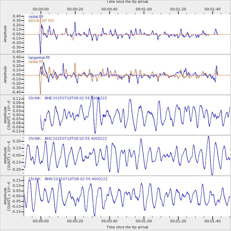
INK INUVIK, NT - Earthquake Result Viewer
*The percent match for this event was below the threshold and hence no stack was calculated.
| Earthquake location: |
Minahassa Peninsula, Sulawesi |
| Earthquake latitude/longitude: |
1.0/122.8 |
| Earthquake time(UTC): |
2015/07/19 (200) 07:50:14 GMT |
| Earthquake Depth: |
50 km |
| Earthquake Magnitude: |
4.7 mb |
| Earthquake Catalog/Contributor: |
ISC/ISC |
|
| Network: |
CN Canadian National Seismograph Network |
| Station: |
INK INUVIK, NT |
| Lat/Lon: |
68.31 N/133.53 W |
| Elevation: |
44 m |
|
| Distance: |
94.1 deg |
| Az: |
21.233 deg |
| Baz: |
283.103 deg |
| Ray Param: |
$rayparam |
*The percent match for this event was below the threshold and hence was not used in the summary stack. |
|
| Radial Match: |
59.91137 % |
| Radial Bump: |
400 |
| Transverse Match: |
57.640335 % |
| Transverse Bump: |
400 |
| SOD ConfigId: |
7422571 |
| Insert Time: |
2019-04-19 21:29:52.568 +0000 |
| GWidth: |
2.5 |
| Max Bumps: |
400 |
| Tol: |
0.001 |
|
Signal To Noise
| Channel | StoN | STA | LTA |
| CN:INK: :BHZ:20150719T08:02:56.400022Z | 1.4742913 | 1.2165621E-7 | 8.251844E-8 |
| CN:INK: :BHN:20150719T08:02:56.400022Z | 0.7548373 | 4.5102173E-8 | 5.975086E-8 |
| CN:INK: :BHE:20150719T08:02:56.400022Z | 2.384274 | 1.0179803E-7 | 4.2695607E-8 |
| Arrivals |
| Ps | |
| PpPs | |
| PsPs/PpSs | |


