You are here: Home > Network List > KR - Kyrgyz Digital Network Stations List
> Station ARLS Aral, Kyrgyzstan > Earthquake Result Viewer
ARLS Aral, Kyrgyzstan - Earthquake Result Viewer
| Earthquake location: |
Southwest Indian Ridge |
| Earthquake latitude/longitude: |
-34.8/54.5 |
| Earthquake time(UTC): |
2015/07/20 (201) 05:28:36 GMT |
| Earthquake Depth: |
10 km |
| Earthquake Magnitude: |
5.6 MB |
| Earthquake Catalog/Contributor: |
NEIC PDE/NEIC COMCAT |
|
| Network: |
KR Kyrgyz Digital Network |
| Station: |
ARLS Aral, Kyrgyzstan |
| Lat/Lon: |
41.87 N/74.33 E |
| Elevation: |
1526 m |
|
| Distance: |
78.5 deg |
| Az: |
14.978 deg |
| Baz: |
196.54 deg |
| Ray Param: |
0.049627032 |
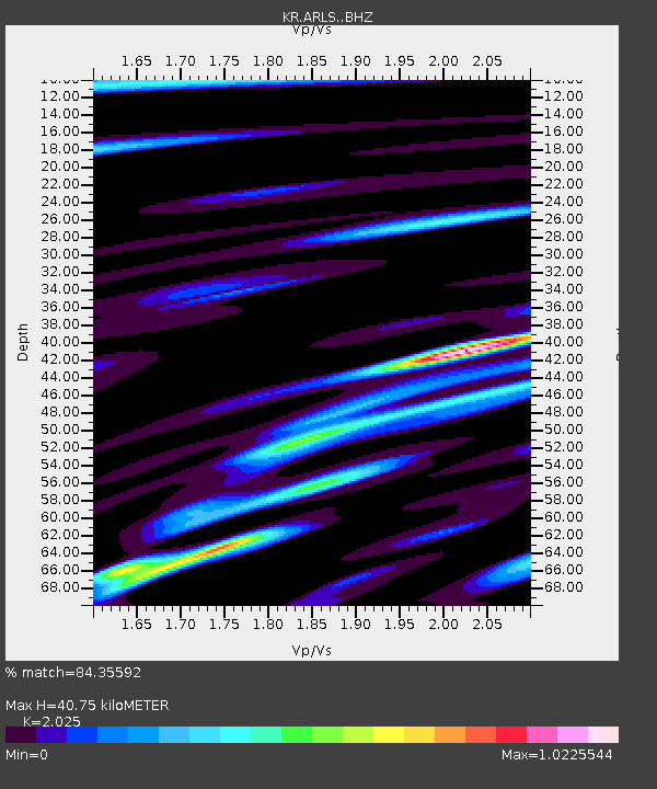
| Estimated Moho Depth: |
40.75 km |
| Estimated Crust Vp/Vs: |
2.03 |
| Assumed Crust Vp: |
6.491 km/s |
| Estimated Crust Vs: |
3.205 km/s |
| Estimated Crust Poisson's Ratio: |
0.34 |
|
| Radial Match: |
84.35592 % |
| Radial Bump: |
400 |
| Transverse Match: |
60.98104 % |
| Transverse Bump: |
400 |
| SOD ConfigId: |
7422571 |
| Insert Time: |
2019-04-19 21:33:50.754 +0000 |
| GWidth: |
2.5 |
| Max Bumps: |
400 |
| Tol: |
0.001 |
|

Signal To Noise
| Channel | StoN | STA | LTA |
| KR:ARLS: :BHZ:20150720T05:40:04.950024Z | 5.3793387 | 3.0929004E-7 | 5.7495924E-8 |
| KR:ARLS: :BHN:20150720T05:40:04.950024Z | 3.2345939 | 1.1131578E-7 | 3.4414143E-8 |
| KR:ARLS: :BHE:20150720T05:40:04.950024Z | 1.5043534 | 7.85723E-8 | 5.2229947E-8 |
| Arrivals |
| Ps | 6.6 SECOND |
| PpPs | 18 SECOND |
| PsPs/PpSs | 25 SECOND |


