You are here: Home > Network List > LD - Lamont-Doherty Cooperative Seismographic Network Stations List
> Station MVL Millersville University, PA > Earthquake Result Viewer
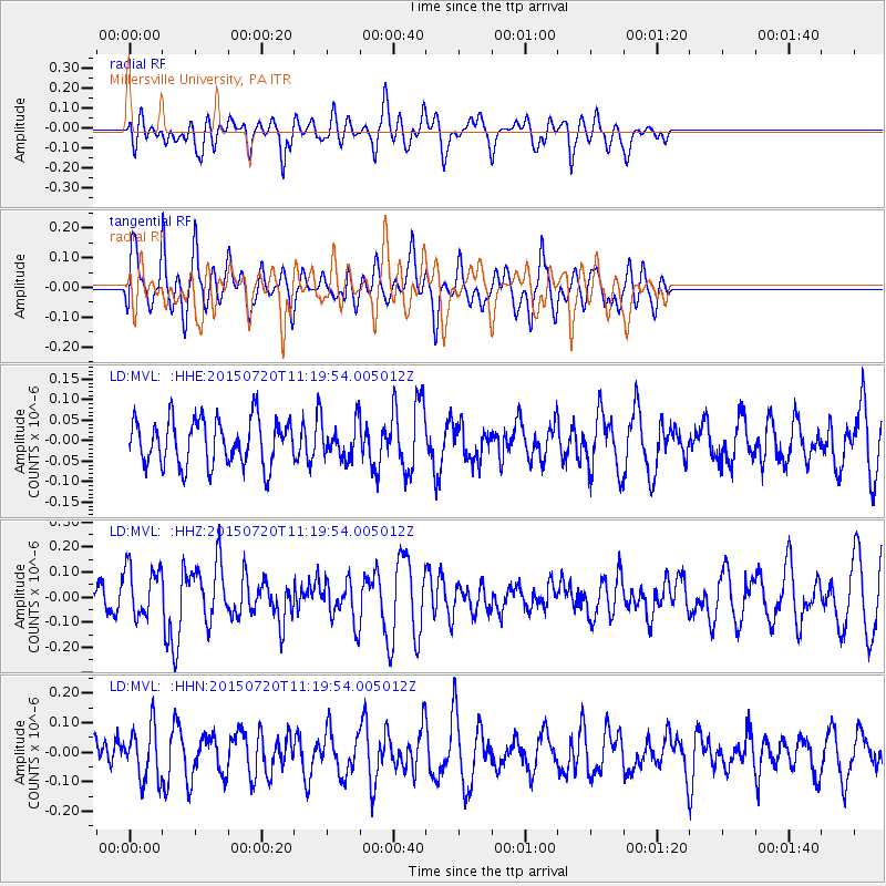
MVL Millersville University, PA - Earthquake Result Viewer
*The percent match for this event was below the threshold and hence no stack was calculated.
| Earthquake location: |
Southern East Pacific Rise |
| Earthquake latitude/longitude: |
-35.5/-105.1 |
| Earthquake time(UTC): |
2015/07/20 (201) 11:08:18 GMT |
| Earthquake Depth: |
13 km |
| Earthquake Magnitude: |
5.8 MW |
| Earthquake Catalog/Contributor: |
ISC/ISC |
|
| Network: |
LD Lamont-Doherty Cooperative Seismographic Network |
| Station: |
MVL Millersville University, PA |
| Lat/Lon: |
40.00 N/76.35 W |
| Elevation: |
91 m |
|
| Distance: |
79.6 deg |
| Az: |
22.055 deg |
| Baz: |
203.514 deg |
| Ray Param: |
$rayparam |
*The percent match for this event was below the threshold and hence was not used in the summary stack. |
|
| Radial Match: |
59.46511 % |
| Radial Bump: |
400 |
| Transverse Match: |
72.407745 % |
| Transverse Bump: |
400 |
| SOD ConfigId: |
7422571 |
| Insert Time: |
2019-04-19 21:38:29.350 +0000 |
| GWidth: |
2.5 |
| Max Bumps: |
400 |
| Tol: |
0.001 |
|
Signal To Noise
| Channel | StoN | STA | LTA |
| LD:MVL: :HHZ:20150720T11:19:54.005012Z | 1.4962022 | 1.0022621E-7 | 6.698707E-8 |
| LD:MVL: :HHN:20150720T11:19:54.005012Z | 1.2824668 | 8.919097E-8 | 6.954642E-8 |
| LD:MVL: :HHE:20150720T11:19:54.005012Z | 0.7996428 | 4.456743E-8 | 5.573417E-8 |
| Arrivals |
| Ps | |
| PpPs | |
| PsPs/PpSs | |


