You are here: Home > Network List > CI - Caltech Regional Seismic Network Stations List
> Station GLA Glamis, California, USA > Earthquake Result Viewer
GLA Glamis, California, USA - Earthquake Result Viewer
| Earthquake location: |
Jujuy Province, Argentina |
| Earthquake latitude/longitude: |
-23.5/-66.5 |
| Earthquake time(UTC): |
2000/05/12 (133) 18:43:18 GMT |
| Earthquake Depth: |
225 km |
| Earthquake Magnitude: |
6.2 MB, 7.2 MW, 7.1 MW |
| Earthquake Catalog/Contributor: |
WHDF/NEIC |
|
| Network: |
CI Caltech Regional Seismic Network |
| Station: |
GLA Glamis, California, USA |
| Lat/Lon: |
33.05 N/114.83 W |
| Elevation: |
627 m |
|
| Distance: |
72.8 deg |
| Az: |
318.905 deg |
| Baz: |
134.09 deg |
| Ray Param: |
0.052833475 |
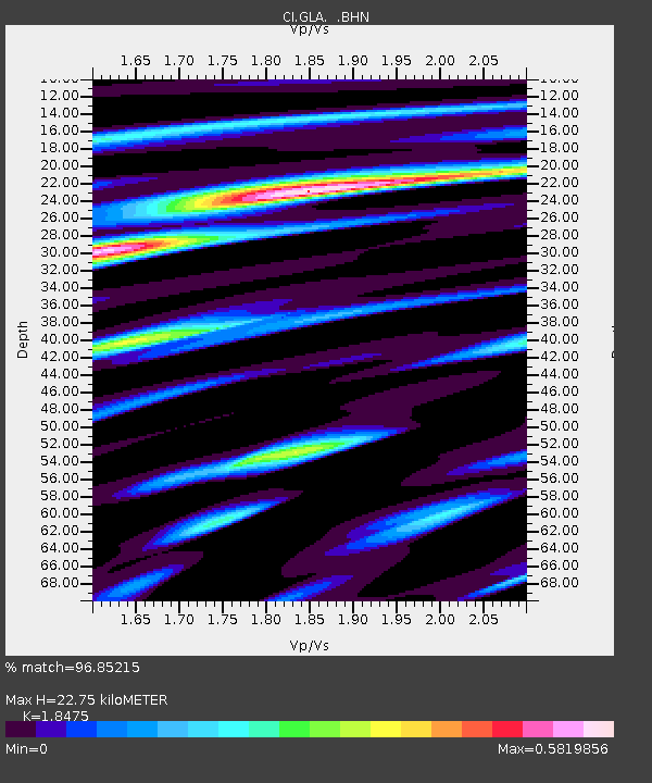
| Estimated Moho Depth: |
22.75 km |
| Estimated Crust Vp/Vs: |
1.85 |
| Assumed Crust Vp: |
6.155 km/s |
| Estimated Crust Vs: |
3.331 km/s |
| Estimated Crust Poisson's Ratio: |
0.29 |
|
| Radial Match: |
96.85215 % |
| Radial Bump: |
400 |
| Transverse Match: |
81.45663 % |
| Transverse Bump: |
400 |
| SOD ConfigId: |
3744 |
| Insert Time: |
2010-02-25 21:42:16.941 +0000 |
| GWidth: |
2.5 |
| Max Bumps: |
400 |
| Tol: |
0.001 |
|
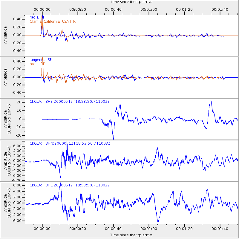
Signal To Noise
| Channel | StoN | STA | LTA |
| CI:GLA: :BHN:20000512T18:53:50.711003Z | 1.2295989 | 5.1512376E-7 | 4.1893642E-7 |
| CI:GLA: :BHE:20000512T18:53:50.711003Z | 2.717083 | 4.6923387E-7 | 1.7269765E-7 |
| CI:GLA: :BHZ:20000512T18:53:50.711003Z | 6.9665866 | 1.9316092E-6 | 2.7726767E-7 |
| Arrivals |
| Ps | 3.2 SECOND |
| PpPs | 10 SECOND |
| PsPs/PpSs | 13 SECOND |


