You are here: Home > Network List > TA - USArray Transportable Network (new EarthScope stations) Stations List
> Station J20K Nowitna River, AK, USA > Earthquake Result Viewer
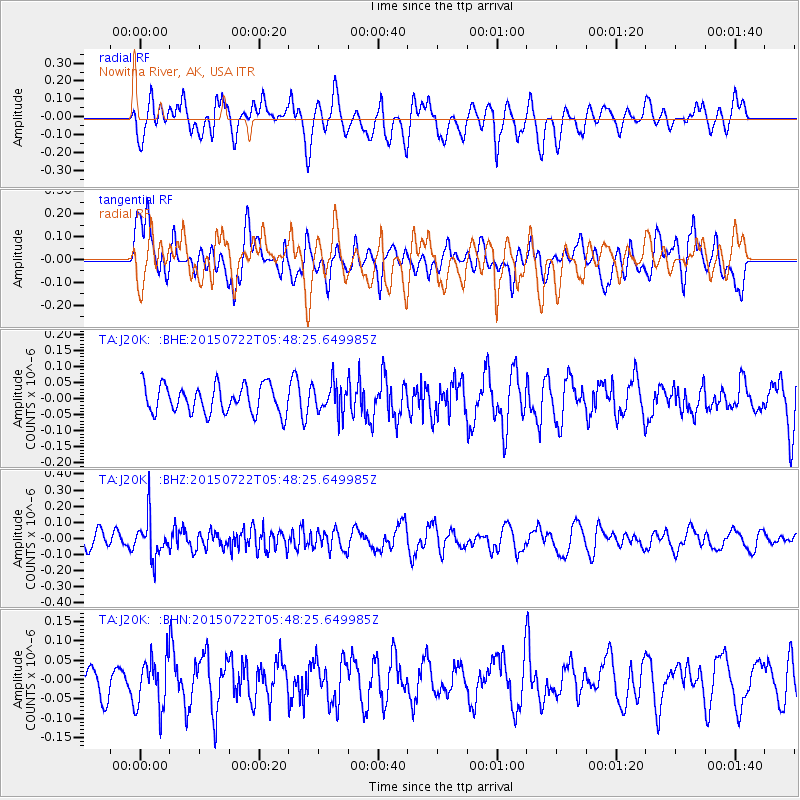
J20K Nowitna River, AK, USA - Earthquake Result Viewer
*The percent match for this event was below the threshold and hence no stack was calculated.
| Earthquake location: |
Northern Sumatra, Indonesia |
| Earthquake latitude/longitude: |
5.0/94.8 |
| Earthquake time(UTC): |
2015/07/22 (203) 05:35:43 GMT |
| Earthquake Depth: |
53 km |
| Earthquake Magnitude: |
5.6 MB |
| Earthquake Catalog/Contributor: |
NEIC PDE/NEIC COMCAT |
|
| Network: |
TA USArray Transportable Network (new EarthScope stations) |
| Station: |
J20K Nowitna River, AK, USA |
| Lat/Lon: |
64.18 N/154.15 W |
| Elevation: |
314 m |
|
| Distance: |
94.5 deg |
| Az: |
24.2 deg |
| Baz: |
291.185 deg |
| Ray Param: |
$rayparam |
*The percent match for this event was below the threshold and hence was not used in the summary stack. |
|
| Radial Match: |
53.097343 % |
| Radial Bump: |
400 |
| Transverse Match: |
62.57707 % |
| Transverse Bump: |
400 |
| SOD ConfigId: |
7422571 |
| Insert Time: |
2019-04-19 21:56:17.500 +0000 |
| GWidth: |
2.5 |
| Max Bumps: |
400 |
| Tol: |
0.001 |
|
Signal To Noise
| Channel | StoN | STA | LTA |
| TA:J20K: :BHZ:20150722T05:48:25.649985Z | 2.4325645 | 1.194918E-7 | 4.9121738E-8 |
| TA:J20K: :BHN:20150722T05:48:25.649985Z | 1.343016 | 6.5664985E-8 | 4.889367E-8 |
| TA:J20K: :BHE:20150722T05:48:25.649985Z | 1.154512 | 4.9964278E-8 | 4.3277396E-8 |
| Arrivals |
| Ps | |
| PpPs | |
| PsPs/PpSs | |


