You are here: Home > Network List > AG - Arkansas Seismic Network Stations List
> Station HHAR Hobbs,AR > Earthquake Result Viewer
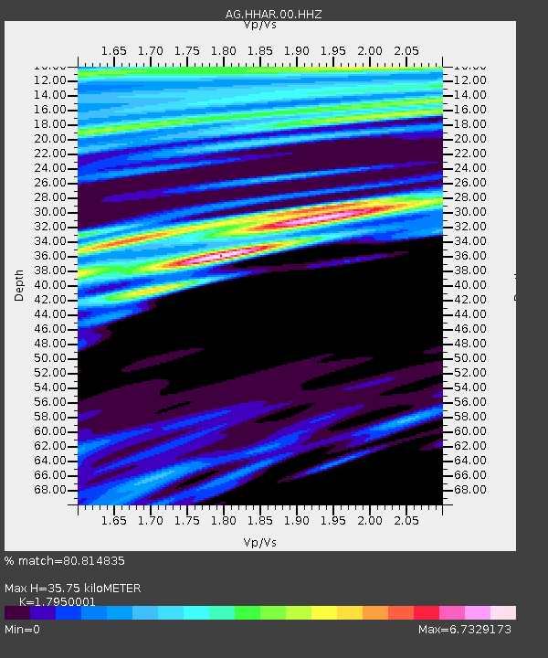
HHAR Hobbs,AR - Earthquake Result Viewer
| Earthquake location: |
Kuril Islands |
| Earthquake latitude/longitude: |
44.3/148.1 |
| Earthquake time(UTC): |
2015/07/22 (203) 06:03:56 GMT |
| Earthquake Depth: |
106 km |
| Earthquake Magnitude: |
3.7 mb |
| Earthquake Catalog/Contributor: |
ISC/ISC |
|
| Network: |
AG Arkansas Seismic Network |
| Station: |
HHAR Hobbs,AR |
| Lat/Lon: |
36.28 N/93.94 W |
| Elevation: |
421 m |
|
| Distance: |
82.1 deg |
| Az: |
46.09 deg |
| Baz: |
320.191 deg |
| Ray Param: |
0.04690642 |
| Estimated Moho Depth: |
35.75 km |
| Estimated Crust Vp/Vs: |
1.80 |
| Assumed Crust Vp: |
6.53 km/s |
| Estimated Crust Vs: |
3.638 km/s |
| Estimated Crust Poisson's Ratio: |
0.27 |
|
| Radial Match: |
80.814835 % |
| Radial Bump: |
400 |
| Transverse Match: |
81.16509 % |
| Transverse Bump: |
400 |
| SOD ConfigId: |
7422571 |
| Insert Time: |
2019-04-19 21:58:00.909 +0000 |
| GWidth: |
2.5 |
| Max Bumps: |
400 |
| Tol: |
0.001 |
|

Signal To Noise
| Channel | StoN | STA | LTA |
| AG:HHAR:00:HHZ:20150722T06:15:34.185Z | 0.8463285 | 4.557381E-8 | 5.3848844E-8 |
| AG:HHAR:00:HHN:20150722T06:15:34.185Z | 1.7318054 | 1.5227322E-7 | 8.792744E-8 |
| AG:HHAR:00:HHE:20150722T06:15:34.185Z | 2.1672595 | 6.1264046E-7 | 2.826798E-7 |
| Arrivals |
| Ps | 4.5 SECOND |
| PpPs | 15 SECOND |
| PsPs/PpSs | 19 SECOND |


