You are here: Home > Network List > NM - Cooperative New Madrid Seismic Network Stations List
> Station SLM St. Louis, MO > Earthquake Result Viewer
SLM St. Louis, MO - Earthquake Result Viewer
| Earthquake location: |
Kuril Islands |
| Earthquake latitude/longitude: |
48.1/153.9 |
| Earthquake time(UTC): |
2015/07/23 (204) 14:54:10 GMT |
| Earthquake Depth: |
100 km |
| Earthquake Magnitude: |
4.3 mb |
| Earthquake Catalog/Contributor: |
ISC/ISC |
|
| Network: |
NM Cooperative New Madrid Seismic Network |
| Station: |
SLM St. Louis, MO |
| Lat/Lon: |
38.64 N/90.24 W |
| Elevation: |
186 m |
|
| Distance: |
76.6 deg |
| Az: |
46.412 deg |
| Baz: |
321.646 deg |
| Ray Param: |
0.050653514 |
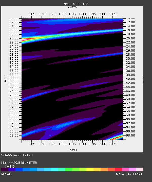
| Estimated Moho Depth: |
20.5 km |
| Estimated Crust Vp/Vs: |
1.60 |
| Assumed Crust Vp: |
6.498 km/s |
| Estimated Crust Vs: |
4.061 km/s |
| Estimated Crust Poisson's Ratio: |
0.18 |
|
| Radial Match: |
96.42178 % |
| Radial Bump: |
294 |
| Transverse Match: |
97.93274 % |
| Transverse Bump: |
169 |
| SOD ConfigId: |
7422571 |
| Insert Time: |
2019-04-19 22:18:22.021 +0000 |
| GWidth: |
2.5 |
| Max Bumps: |
400 |
| Tol: |
0.001 |
|

Signal To Noise
| Channel | StoN | STA | LTA |
| NM:SLM:00:HHZ:20150723T15:05:19.498987Z | 1.2210273 | 8.1871787E-7 | 6.7051565E-7 |
| NM:SLM:00:HHN:20150723T15:05:19.498987Z | 0.70966434 | 1.2276371E-7 | 1.7298841E-7 |
| NM:SLM:00:HHE:20150723T15:05:19.498987Z | 1.2451351 | 1.1453558E-6 | 9.198647E-7 |
| Arrivals |
| Ps | 2.0 SECOND |
| PpPs | 7.9 SECOND |
| PsPs/PpSs | 9.9 SECOND |


