You are here: Home > Network List > X812 - Deep Structure of Three Continental Sutures in Eastern North America Stations List
> Station QM12 Camp Vic, Maine, USA > Earthquake Result Viewer
QM12 Camp Vic, Maine, USA - Earthquake Result Viewer
| Earthquake location: |
Kuril Islands |
| Earthquake latitude/longitude: |
48.1/153.9 |
| Earthquake time(UTC): |
2015/07/23 (204) 14:54:10 GMT |
| Earthquake Depth: |
100 km |
| Earthquake Magnitude: |
4.3 mb |
| Earthquake Catalog/Contributor: |
ISC/ISC |
|
| Network: |
X8 Deep Structure of Three Continental Sutures in Eastern North America |
| Station: |
QM12 Camp Vic, Maine, USA |
| Lat/Lon: |
44.97 N/67.86 W |
| Elevation: |
15 m |
|
| Distance: |
80.4 deg |
| Az: |
28.641 deg |
| Baz: |
333.06 deg |
| Ray Param: |
0.048091434 |
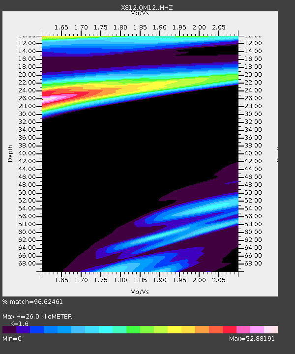
| Estimated Moho Depth: |
26.0 km |
| Estimated Crust Vp/Vs: |
1.60 |
| Assumed Crust Vp: |
6.419 km/s |
| Estimated Crust Vs: |
4.012 km/s |
| Estimated Crust Poisson's Ratio: |
0.18 |
|
| Radial Match: |
96.62461 % |
| Radial Bump: |
369 |
| Transverse Match: |
96.621254 % |
| Transverse Bump: |
379 |
| SOD ConfigId: |
7422571 |
| Insert Time: |
2019-04-19 22:20:46.794 +0000 |
| GWidth: |
2.5 |
| Max Bumps: |
400 |
| Tol: |
0.001 |
|

Signal To Noise
| Channel | StoN | STA | LTA |
| X8:QM12: :HHZ:20150723T15:05:40.225Z | 2.1658065 | 2.3996874E-6 | 1.1079878E-6 |
| X8:QM12: :HHN:20150723T15:05:40.225Z | 2.3130763 | 5.3305186E-5 | 2.3045148E-5 |
| X8:QM12: :HHE:20150723T15:05:40.225Z | 3.0866964 | 3.723641E-4 | 1.2063516E-4 |
| Arrivals |
| Ps | 2.5 SECOND |
| PpPs | 10 SECOND |
| PsPs/PpSs | 13 SECOND |


