You are here: Home > Network List > TA - USArray Transportable Network (new EarthScope stations) Stations List
> Station J01E Myrtle Point, OR, USA > Earthquake Result Viewer
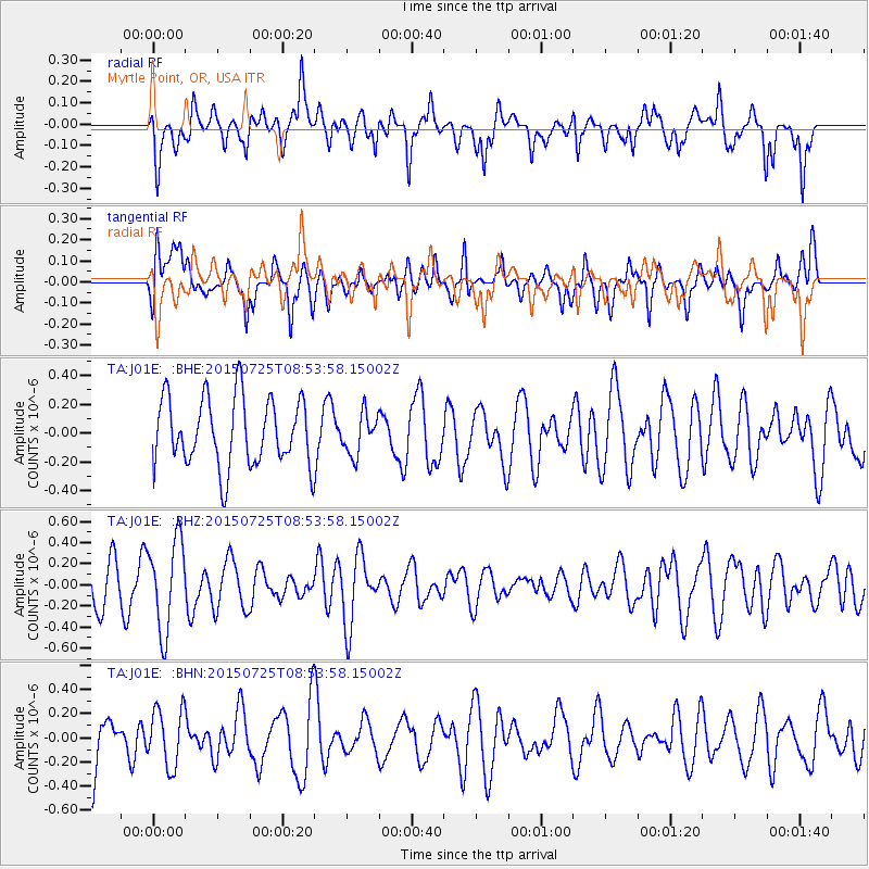
J01E Myrtle Point, OR, USA - Earthquake Result Viewer
*The percent match for this event was below the threshold and hence no stack was calculated.
| Earthquake location: |
Samar, Philippines |
| Earthquake latitude/longitude: |
12.8/124.8 |
| Earthquake time(UTC): |
2015/07/25 (206) 08:41:09 GMT |
| Earthquake Depth: |
71 km |
| Earthquake Magnitude: |
4.9 MW |
| Earthquake Catalog/Contributor: |
ISC/ISC |
|
| Network: |
TA USArray Transportable Network (new EarthScope stations) |
| Station: |
J01E Myrtle Point, OR, USA |
| Lat/Lon: |
43.16 N/123.93 W |
| Elevation: |
128 m |
|
| Distance: |
96.2 deg |
| Az: |
43.319 deg |
| Baz: |
293.874 deg |
| Ray Param: |
$rayparam |
*The percent match for this event was below the threshold and hence was not used in the summary stack. |
|
| Radial Match: |
63.409817 % |
| Radial Bump: |
400 |
| Transverse Match: |
54.96584 % |
| Transverse Bump: |
400 |
| SOD ConfigId: |
7422571 |
| Insert Time: |
2019-04-19 22:46:08.704 +0000 |
| GWidth: |
2.5 |
| Max Bumps: |
400 |
| Tol: |
0.001 |
|
Signal To Noise
| Channel | StoN | STA | LTA |
| TA:J01E: :BHZ:20150725T08:53:58.15002Z | 2.1908367 | 4.2403263E-7 | 1.9354827E-7 |
| TA:J01E: :BHN:20150725T08:53:58.15002Z | 1.1142913 | 2.392409E-7 | 2.147023E-7 |
| TA:J01E: :BHE:20150725T08:53:58.15002Z | 0.5907785 | 1.4048759E-7 | 2.3780075E-7 |
| Arrivals |
| Ps | |
| PpPs | |
| PsPs/PpSs | |


