You are here: Home > Network List > TA - USArray Transportable Network (new EarthScope stations) Stations List
> Station MSTX Muleshoe, TX, USA > Earthquake Result Viewer
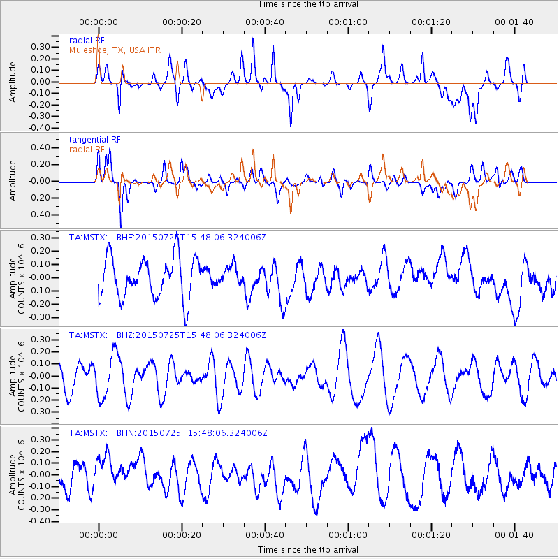
MSTX Muleshoe, TX, USA - Earthquake Result Viewer
*The percent match for this event was below the threshold and hence no stack was calculated.
| Earthquake location: |
Kuril Islands |
| Earthquake latitude/longitude: |
43.8/146.2 |
| Earthquake time(UTC): |
2015/07/25 (206) 15:36:38 GMT |
| Earthquake Depth: |
105 km |
| Earthquake Magnitude: |
3.7 mb |
| Earthquake Catalog/Contributor: |
ISC/ISC |
|
| Network: |
TA USArray Transportable Network (new EarthScope stations) |
| Station: |
MSTX Muleshoe, TX, USA |
| Lat/Lon: |
33.97 N/102.77 W |
| Elevation: |
1167 m |
|
| Distance: |
80.3 deg |
| Az: |
51.923 deg |
| Baz: |
316.737 deg |
| Ray Param: |
$rayparam |
*The percent match for this event was below the threshold and hence was not used in the summary stack. |
|
| Radial Match: |
55.712646 % |
| Radial Bump: |
400 |
| Transverse Match: |
71.92216 % |
| Transverse Bump: |
400 |
| SOD ConfigId: |
7422571 |
| Insert Time: |
2019-04-19 22:53:58.906 +0000 |
| GWidth: |
2.5 |
| Max Bumps: |
400 |
| Tol: |
0.001 |
|
Signal To Noise
| Channel | StoN | STA | LTA |
| TA:MSTX: :BHZ:20150725T15:48:06.324006Z | 1.3532478 | 1.8512394E-7 | 1.3679973E-7 |
| TA:MSTX: :BHN:20150725T15:48:06.324006Z | 1.4684331 | 1.4583217E-7 | 9.9311414E-8 |
| TA:MSTX: :BHE:20150725T15:48:06.324006Z | 0.49360588 | 7.581829E-8 | 1.5360087E-7 |
| Arrivals |
| Ps | |
| PpPs | |
| PsPs/PpSs | |


