You are here: Home > Network List > TA - USArray Transportable Network (new EarthScope stations) Stations List
> Station I23K Minto, Yukon-Koyukuk, AK, USA > Earthquake Result Viewer
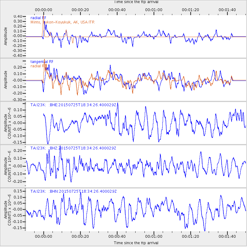
I23K Minto, Yukon-Koyukuk, AK, USA - Earthquake Result Viewer
*The percent match for this event was below the threshold and hence no stack was calculated.
| Earthquake location: |
Near North Coast Of Irian Jaya |
| Earthquake latitude/longitude: |
-2.7/139.2 |
| Earthquake time(UTC): |
2015/07/25 (206) 18:22:27 GMT |
| Earthquake Depth: |
37 km |
| Earthquake Magnitude: |
5.2 MW |
| Earthquake Catalog/Contributor: |
ISC/ISC |
|
| Network: |
TA USArray Transportable Network (new EarthScope stations) |
| Station: |
I23K Minto, Yukon-Koyukuk, AK, USA |
| Lat/Lon: |
65.15 N/149.36 W |
| Elevation: |
149 m |
|
| Distance: |
84.7 deg |
| Az: |
23.722 deg |
| Baz: |
251.973 deg |
| Ray Param: |
$rayparam |
*The percent match for this event was below the threshold and hence was not used in the summary stack. |
|
| Radial Match: |
50.68657 % |
| Radial Bump: |
400 |
| Transverse Match: |
42.445816 % |
| Transverse Bump: |
400 |
| SOD ConfigId: |
7422571 |
| Insert Time: |
2019-04-19 22:58:24.973 +0000 |
| GWidth: |
2.5 |
| Max Bumps: |
400 |
| Tol: |
0.001 |
|
Signal To Noise
| Channel | StoN | STA | LTA |
| TA:I23K: :BHZ:20150725T18:34:26.400029Z | 2.3810196 | 1.0572553E-7 | 4.4403475E-8 |
| TA:I23K: :BHN:20150725T18:34:26.400029Z | 1.0724413 | 5.4063435E-8 | 5.041155E-8 |
| TA:I23K: :BHE:20150725T18:34:26.400029Z | 1.0592833 | 5.4418877E-8 | 5.13733E-8 |
| Arrivals |
| Ps | |
| PpPs | |
| PsPs/PpSs | |


