You are here: Home > Network List > KO - Kandilli Observatory Digital Broadband Seismic Network Stations List
> Station KARS Kars-Turkey > Earthquake Result Viewer
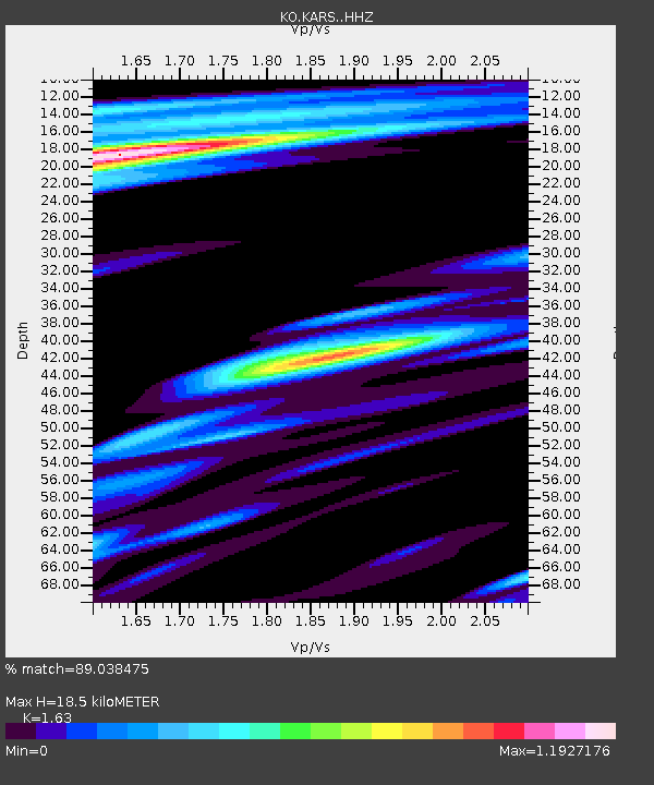
KARS Kars-Turkey - Earthquake Result Viewer
| Earthquake location: |
South Of Java, Indonesia |
| Earthquake latitude/longitude: |
-9.2/112.7 |
| Earthquake time(UTC): |
2015/07/26 (207) 07:05:08 GMT |
| Earthquake Depth: |
59 km |
| Earthquake Magnitude: |
6.0 MWP |
| Earthquake Catalog/Contributor: |
NEIC PDE/NEIC COMCAT |
|
| Network: |
KO Kandilli Observatory Digital Broadband Seismic Network |
| Station: |
KARS Kars-Turkey |
| Lat/Lon: |
40.62 N/43.09 E |
| Elevation: |
1747 m |
|
| Distance: |
80.9 deg |
| Az: |
313.727 deg |
| Baz: |
110.43 deg |
| Ray Param: |
0.04786122 |
| Estimated Moho Depth: |
18.5 km |
| Estimated Crust Vp/Vs: |
1.63 |
| Assumed Crust Vp: |
6.419 km/s |
| Estimated Crust Vs: |
3.938 km/s |
| Estimated Crust Poisson's Ratio: |
0.20 |
|
| Radial Match: |
89.038475 % |
| Radial Bump: |
400 |
| Transverse Match: |
83.8456 % |
| Transverse Bump: |
400 |
| SOD ConfigId: |
7422571 |
| Insert Time: |
2019-04-19 23:01:55.215 +0000 |
| GWidth: |
2.5 |
| Max Bumps: |
400 |
| Tol: |
0.001 |
|

Signal To Noise
| Channel | StoN | STA | LTA |
| KO:KARS: :HHZ:20150726T07:16:44.639973Z | 12.159886 | 4.9597224E-6 | 4.0787575E-7 |
| KO:KARS: :HHN:20150726T07:16:44.639973Z | 3.4108522 | 9.3942566E-7 | 2.7542256E-7 |
| KO:KARS: :HHE:20150726T07:16:44.639973Z | 3.35021 | 1.0769276E-6 | 3.2145076E-7 |
| Arrivals |
| Ps | 1.9 SECOND |
| PpPs | 7.4 SECOND |
| PsPs/PpSs | 9.2 SECOND |


