You are here: Home > Network List > KZ - Kazakhstan Network Stations List
> Station ABKAR Akbulak array,AB31, Kazakhstan > Earthquake Result Viewer
ABKAR Akbulak array,AB31, Kazakhstan - Earthquake Result Viewer
| Earthquake location: |
South Of Java, Indonesia |
| Earthquake latitude/longitude: |
-9.2/112.7 |
| Earthquake time(UTC): |
2015/07/26 (207) 07:05:08 GMT |
| Earthquake Depth: |
59 km |
| Earthquake Magnitude: |
6.0 MWP |
| Earthquake Catalog/Contributor: |
NEIC PDE/NEIC COMCAT |
|
| Network: |
KZ Kazakhstan Network |
| Station: |
ABKAR Akbulak array,AB31, Kazakhstan |
| Lat/Lon: |
49.26 N/59.94 E |
| Elevation: |
362 m |
|
| Distance: |
74.3 deg |
| Az: |
327.194 deg |
| Baz: |
125.282 deg |
| Ray Param: |
0.05231653 |
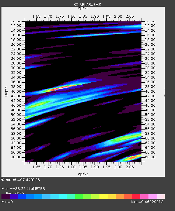
| Estimated Moho Depth: |
38.25 km |
| Estimated Crust Vp/Vs: |
1.77 |
| Assumed Crust Vp: |
6.35 km/s |
| Estimated Crust Vs: |
3.593 km/s |
| Estimated Crust Poisson's Ratio: |
0.26 |
|
| Radial Match: |
97.448135 % |
| Radial Bump: |
322 |
| Transverse Match: |
89.43627 % |
| Transverse Bump: |
400 |
| SOD ConfigId: |
7422571 |
| Insert Time: |
2019-04-19 23:02:05.039 +0000 |
| GWidth: |
2.5 |
| Max Bumps: |
400 |
| Tol: |
0.001 |
|

Signal To Noise
| Channel | StoN | STA | LTA |
| KZ:ABKAR: :BHZ:20150726T07:16:07.951008Z | 209.80634 | 1.1325526E-5 | 5.3980862E-8 |
| KZ:ABKAR: :BHN:20150726T07:16:07.951008Z | 49.79416 | 2.3178784E-6 | 4.6549204E-8 |
| KZ:ABKAR: :BHE:20150726T07:16:07.951008Z | 107.66113 | 4.060511E-6 | 3.771566E-8 |
| Arrivals |
| Ps | 4.8 SECOND |
| PpPs | 16 SECOND |
| PsPs/PpSs | 21 SECOND |


