You are here: Home > Network List > CI - Caltech Regional Seismic Network Stations List
> Station GLA Glamis, California, USA > Earthquake Result Viewer
GLA Glamis, California, USA - Earthquake Result Viewer
| Earthquake location: |
Off Coast Of Central Chile |
| Earthquake latitude/longitude: |
-32.7/-73.1 |
| Earthquake time(UTC): |
2001/04/09 (099) 09:00:57 GMT |
| Earthquake Depth: |
11 km |
| Earthquake Magnitude: |
6.1 MB, 6.3 MS, 6.7 MW, 6.3 ME |
| Earthquake Catalog/Contributor: |
WHDF/NEIC |
|
| Network: |
CI Caltech Regional Seismic Network |
| Station: |
GLA Glamis, California, USA |
| Lat/Lon: |
33.05 N/114.83 W |
| Elevation: |
627 m |
|
| Distance: |
76.3 deg |
| Az: |
324.88 deg |
| Baz: |
144.706 deg |
| Ray Param: |
0.051097028 |
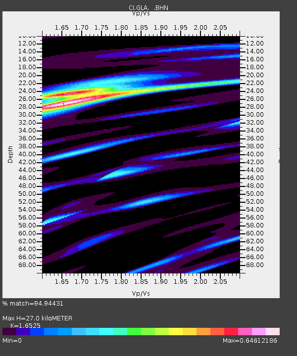
| Estimated Moho Depth: |
27.0 km |
| Estimated Crust Vp/Vs: |
1.65 |
| Assumed Crust Vp: |
6.155 km/s |
| Estimated Crust Vs: |
3.724 km/s |
| Estimated Crust Poisson's Ratio: |
0.21 |
|
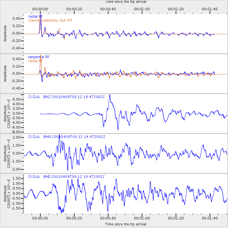
| Radial Match: |
94.94431 % |
| Radial Bump: |
400 |
| Transverse Match: |
83.379814 % |
| Transverse Bump: |
400 |
| SOD ConfigId: |
3770 |
| Insert Time: |
2010-02-25 21:42:55.651 +0000 |
| GWidth: |
2.5 |
| Max Bumps: |
400 |
| Tol: |
0.001 |
|
Signal To Noise
| Channel | StoN | STA | LTA |
| CI:GLA: :BHN:20010409T09:12:14.472002Z | 1.5958066 | 2.3304129E-7 | 1.4603354E-7 |
| CI:GLA: :BHE:20010409T09:12:14.472002Z | 0.95007366 | 1.7983145E-7 | 1.8928158E-7 |
| CI:GLA: :BHZ:20010409T09:12:14.472002Z | 1.2186775 | 3.0481326E-7 | 2.5011806E-7 |
| Arrivals |
| Ps | 3.0 SECOND |
| PpPs | 11 SECOND |
| PsPs/PpSs | 14 SECOND |


